List of counties of Prince Edward Island
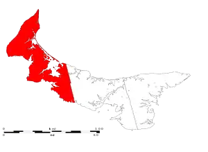
The Canadian province of Prince Edward Island has three counties that have historically been used as administrative divisions for the provincial government, and prior to Confederation (in 1873), the colonial government.

The current system of land division in Prince Edward Island, including its three counties, dates to a series of surveys undertaken in 1764-65 by Captain Samuel Holland of the British Army's Corps of Royal Engineers. Holland's survey saw the island divided into the three counties, each of which had a "royalty" (or shire town) as a county seat. The rest of the county outside the royalty was sub-divided into parishes for the Church of England, measuring approximately 60,000 acres (240 km2); the parishes were further sub-divided into townships measuring approximately 20,000 acres (81 km2).
The counties are no longer used as administrative boundaries for the provincial government, however, they continue to be used as census divisions by Statistics Canada for statistical purposes in administering the Canadian census.[1]
| County name | Historical county seat |
Current county seat |
Population (2016)[1] |
Population (2011)[1] |
Change [1] |
Land area (km²)[1] |
Population density[1] |
Map |
|---|---|---|---|---|---|---|---|---|
| Kings | Kings Royalty | Georgetown | 17,160 | 17,990 | −4.6% | 1,686.34 | 10.2/km2 |  |
| Queens | Queens Royalty | Charlottetown | 82,017 | 77,866 | +5.3% | 2,020.48 | 40.6/km2 |  |
| Prince | Prince Royalty | Summerside | 43,730 | 44,348 | −1.4% | 1,979.21 | 22.1/km2 |  |
| Total counties | — | — | 142,907 | 140,204 | +1.9% | 5,686.03 | 25.1/km2 | |
See also
- Administrative divisions of Canada
References
- "Population and dwelling count highlight tables, 2016 Census". Statistics Canada. February 8, 2017. Retrieved March 9, 2017.
