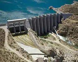
List of dams and reservoirs in Arizona
Following is a list of dams and reservoirs in Arizona.
All major dams are linked below. The National Inventory of Dams defines any "major dam" as being 50 feet (15 m) tall with a storage capacity of at least 5,000 acre feet (6,200,000 m3), or of any height with a storage capacity of 25,000 acre feet (31,000,000 m3).[1]
Dams and reservoirs in Arizona
- This list is incomplete. You can help Wikipedia by expanding it.
- Alamo Dam, Alamo Lake, United States Army Corps of Engineers
- Ashfork-Bainbridge Steel Dam, Steel Dam Reservoir, privately owned
- Bartlett Dam, Bartlett Lake, United States Bureau of Reclamation
- Cave Buttes Dam, Cave Creek Reservoir, Flood Control District of Maricopa County
- Childs-Irving Hydroelectric Facilities, Stehr Lake, privately owned
- Coolidge Dam, San Carlos Lake, United States Bureau of Indian Affairs
- Davis Dam, Lake Mohave, USBR
- Gillespie Dam, unnamed reservoir, privately owned
- Glen Canyon Dam, Lake Powell, USBR
- Granite Basin Dam, Granite Basin Lake, United States Forest Service
- Granite Reef Diversion Dam, unnamed reservoir of the Salt River, USBR
- Headgate Rock Dam, unnamed reservoir, Flood Control District of Maricopa County
- Hoover Dam, Lake Mead, USBR
- Horse Mesa Dam, Apache Lake, USBR
- Horseshoe Dam, Horseshoe Lake, USBR
- Imperial Dam, Imperial Reservoir, USBR
- Laguna Diversion Dam, unnamed reservoir of the Colorado River, USBR (on California border)
- Lyman Dam, Lyman Reservoir, privately owned
- Morelos Dam, unnamed reservoir of the Colorado River, International Boundary and Water Commission (on Mexican border)
- Mormon Flat Dam, Canyon Lake, USBR
- New Cornelia Tailings Dam, largest US dam by volume, privately owned
- New Waddell Dam, Lake Pleasant, USBR
- Painted Rock Dam, Painted Rock Reservoir, USACE
- Palo Verde Dam, diversion dam on the Colorado River, USBR
- Parker Dam, Lake Havasu, USBR
- Stewart Mountain Dam, Saguaro Lake, USBR
- Theodore Roosevelt Dam, Theodore Roosevelt Lake, USBR
References
- "Major Dams of the United States". National Atlas of the United States. USGS. September 17, 2009. Archived from the original on August 14, 2009. Retrieved October 24, 2009.
This article is issued from Wikipedia. The text is licensed under Creative Commons - Attribution - Sharealike. Additional terms may apply for the media files.


