List of historic places in Cape Breton Regional Municipality
List of historic places
| Name | Address | Coordinates | IDF | IDP | IDM | Image | |
|---|---|---|---|---|---|---|---|
| Arts Building | 196 George Street, Sydney, NS | 46°08′N 60°11′W | 2886 |  | |||
| Bank of Montreal | 175 Charlotte Street, Sydney, NS | 46°08′27″N 60°11′43″W | 9325 |  | |||
| Richard Brown House | 32 Brown Street, Sydney Mines, NS | 46°14′07″N 60°13′25″W | 2988 |  | |||
| Chapel Point Battery Site | Church Street and Amber Drive, Sydney Mines, NS | 46°14′39″N 60°12′41″W | 6525 | ||||
| 49 Charlotte Street | 49 Charlotte Street, Sydney, NS | 46°08′38″N 60°11′56″W | 13462 |  | |||
| 79 Charlotte Street | 79 Charlotte Street, Sydney, NS | 46°08′36″N 60°11′54″W | 5163 |  | |||
| CN Train Station | 159 Legatto Street, Sydney Mines, NS | 46°14′41″N 60°14′02″W | 7811 |  | |||
| Cossit House | 75 Charlotte Street, Sydney, NS | 46°08′35″N 60°11′55″W | 1453 | 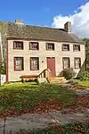 | |||
| Dominion Schoolhouse | 6715 Seaside Drive, Dominion, NS | 46°12′48″N 60°02′02″W | 9324 |  | |||
| Fairholme Farm | Fairholme Farm, 439 Johnson Road, Georges River, NS | 46°13′37″N 60°17′42″W |  | ||||
| Flint Island Lighthouse | , Flint Island, NS | 46°10′44″N 59°48′52″W | 16107 |  | |||
| Fort Petrie | 3479 New Waterford Hwy, New Victoria, NS | 46°14′59″N 60°09′15″W | 2999 | 9310 | .jpg.webp) | ||
| Fortress of Louisbourg National Historic Site of Canada | , Louisbourg, NS | 45°53′33″N 59°59′10″W | 4212 |  | |||
| Gabarus Light Tower | , Gabarus, NS | 45°30′13″N 60°51′02″W | 16106 | .jpg.webp) | |||
| Glace Bay Universal Negro Improvement Association | 35 Jessome Street, Glace Bay, NS | 46°12′16″N 59°57′31″W | 9179 |  | |||
| Highland Arts Theatre (formerly St. Andrew's Church) | 40 Bentinck Street, Sydney, NS | 46°08′19″N 60°11′38″W | 9326 | 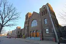 | |||
| Holy Ghost Ukrainian Church | 49 West Street, Whitney Pier, NS | 46°09′28″N 60°10′52″W | 6293 |  | |||
| Jost House | 54 Charlotte Street, Sydney, NS | 46°08′37″N 60°11′55″W | 6528 | 5171 | .jpg.webp) | ||
| Kennedy House | 89 Esplanade Street, Sydney, NS | 46°08′34″N 60°11′55″W | 7964 |  | |||
| Lakeview House | 7271 East Bay Highway, Big Pond, NS | 45°54′36″N 60°32′07″W | 5197 |  | |||
| Louisbourg Navy League Building | 7563 Main Street, Louisbourg, NS | 45°55′08″N 59°58′30″W | 8041 |  | |||
| Light Tower (Low Point Lighthouse) | 39 Lighthouse Road, Low Point Lightstation, New Victoria, NS | 46°16′02″N 60°07′33″W | 13966 | 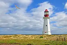 | |||
| Lyceum | 225 George Street, Sydney, NS | 46°08′32″N 60°11′37″W | 7593 |  | |||
| Marconi National Historic Site of Canada | Timmerman and Vivian Streets, Glace Bay, NS | 46°12′40″N 59°57′09″W | 11710 | 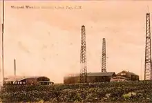 | |||
| Marconi Wireless Station National Historic Site of Canada | Marconi Towers Road, Glace Bay, NS | 46°09′17″N 59°56′45″W | 9370 |  | |||
| Mitchell Island Union Church | 2645 Point Edward Highway, Point Edward, NS | 46°09′53″N 60°16′22″W | 9311 | 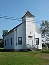 | |||
| Museum and Caretaker's House | Fortress Louisbourg, Louisbourg, Nova Scotia, NS | 45°53′N 60°03′W | 3158 |  | |||
| Old Glace Bay Town Hall | 14 McKeen Street, Glace Bay, NS | 46°11′51″N 59°57′29″W | 5191 |  | |||
| Old Grand Narrows Hotel B&B | 11 Derby Point Road, Grand Narrows, NS | 45°57′19″N 60°47′36″W | 5196 |  | |||
| Old Sydney Mines Post Office | 2 Fraser Avenue, Sydney Mines, NS | 46°14′31″N 60°13′54″W | 6283 |  | |||
| Peters House | 16 Campbell Street, Sydney, NS | 46°08′42″N 60°11′57″W | 5189 |  | |||
| Port Morien Rectory Bed and Breakfast | 2652 Morien Highway, Port Morien, NS | 46°08′12″N 59°52′15″W | 8965 |  | |||
| Royal Battery National Historic Site of Canada | Fortress Louisbourg, Louisbourg, NS | 45°54′33″N 59°58′48″W | 13393 | ||||
| St. George's Church and Graveyard | 119 Charlotte Street, Sydney, NS | 46°08′33″N 60°11′47″W | 5378 |  | |||
| St. Mary's Polish Church | 15 Wesley Street, Whitney Pier, NS | 46°09′29″N 60°11′04″W | 6285 |  | |||
| St. Patrick's Church | 87 Esplanade, Sydney, NS | 46°08′34″N 60°11′55″W | 3295 |  | |||
| St. Philip's African Orthodox Church | 34 Hankard Street, Whitney Pier, NS | 46°09′11″N 60°10′48″W | 6292 |  | |||
| Science Building | 210 George Street, Sydney, NS | 46°08′N 60°11′W | 2899 |  | |||
| Sydney and Louisburg Railway Station | 7330 Main Street, Louisbourg, NS | 45°55′26″N 59°57′49″W | 7813 |  | |||
| Tower (Louisbourg Lighthouse) | Havenside Road, Louisbourg, NS | 45°54′22″N 59°57′31″W | 9654 |  | |||
| Union Presbyterian Church | 4220 Louisbourg Highway, Albert Bridge, NS | 46°01′11″N 60°03′30″W | 15983 | 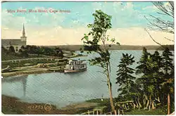 | |||
| Wolfe's Landing National Historic Site of Canada | Kennington Cove, Fortress Louisbourg, Louisbourg, NS | 45°52′42″N 60°03′31″W | 13556 |  |
See also
This article is issued from Wikipedia. The text is licensed under Creative Commons - Attribution - Sharealike. Additional terms may apply for the media files.
