List of historic places in the Thompson-Nicola Regional District
The following list includes all of the Canadian Register of Historic Places listings in Thompson-Nicola Regional District, British Columbia.
| Name | Address | Coordinates | IDF | IDP | IDM | Image | |
|---|---|---|---|---|---|---|---|
| McAbee Fossil Beds Heritage Site | Highway 97, Near Cache Creek, BC | 50°47′50″N 121°08′28″W | 19023 | 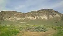 | |||
| Clinton Pioneer Cemetery | 7456 Old Clinton Cemetery Road, Clinton, BC | 51°05′40″N 121°35′16″W | 21454 |  | |||
| Wilson Residence and Sheds | Steelhead Provincial Park, Savona, BC | 50°45′24″N 120°51′57″W | 18044 | | |||
| Ray Farm Cabin | , Near Clearwater, BC | 52°03′30″N 120°09′22″W | 18072 | | |||
| Ray Farm Residence | , Near Clearwater, BC | 52°03′31″N 120°09′22″W | 18046 | | |||
| Hat Creek Ranch | 4061 Sea to Sky Highway, Thompson-Nicola Regional District, Hat Creek, BC | 50°53′07″N 121°24′32″W | 2856 | | |||
| B.C. Sheep Breeders Building | 961 Lorne Street, Kamloops, BC | 50°40′31″N 120°18′58″W | 11832 | 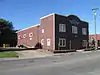 | |||
| Cattle Car and Caboose | 7th Avenue at Front Street, Kamloops, BC | 50°40′43″N 120°19′23″W | 12788 | 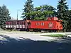 | |||
| CNR Station | 500 Lorne Street, Kamloops, BC | 50°40′44″N 120°19′47″W | 11836 | | |||
| Hayden House | 566 4th Avenue, Kamloops, BC | 50°40′21″N 120°19′55″W | 12787 | 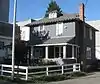 | |||
| Inland Cigar Factory | 295 1st Avenue, Kamloops, BC | 50°40′32″N 120°20′20″W | 12793 |  | |||
| Kamloops Chinese Cemetery | 850 Lombard Street, Kamloops, BC | 50°40′41″N 120°21′35″W | 12794 | | |||
| McIntosh Memorial | 500 block Columbia Street West, Kamloops, BC | 50°40′23″N 120°21′11″W | 11834 |  | |||
| Memorial Arena | 740 Victoria Street, Kamloops, BC | 50°40′35″N 120°19′23″W | 12137 | ||||
| Naval Ammunition Depot Bunkers | 1455 McGill Road, Kamloops, BC | 50°40′31″N 120°23′02″W | 12795 |  | |||
| Old Kamloops Bank of Commerce | 118 Victoria Street, Kamloops, BC | 50°40′35″N 120°20′19″W | 12792 | | |||
| Old Kamloops Courthouse | 7 Seymour Street West, Kamloops, BC | 50°40′30″N 120°20′20″W | 12791 |  | |||
| Pioneer Cemetery | 780 Lorne Street, Kamloops, BC | 50°40′39″N 120°19′13″W | 12785 | | |||
| Plaza Hotel | 405 Victoria Street, Kamloops, BC | 50°40′32″N 120°19′55″W | 11833 | 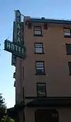 | |||
| St. Andrew's on the Square | 159 Seymour Street, Kamloops, BC | 50°40′29″N 120°20′13″W | 11835 | 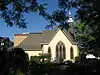 | |||
| Stoodley Residence | 79 Nicola Street West, Kamloops, BC | 50°40′22″N 120°20′28″W | 12798 | 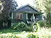 | |||
| Stuart Wood School | 245 St. Paul Street, Kamloops, BC | 50°40′25″N 120°20′10″W | 12790 | | |||
| Tom Bones House | 328 Royal Avenue, Kamloops, BC | 50°41′12″N 120°21′36″W | 12796 | 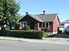 | |||
| W. A. G. Marlatt House | 155 St. Paul Street West, Kamloops, BC | 50°40′30″N 120°20′35″W | 12797 | ||||
| William W. Bishop House | 619 Nicola Street, Kamloops, BC | 50°40′19″N 120°19′34″W | 12786 | 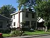 | |||
| Wilson House | 115 Tranquille Road, Kamloops, BC | 50°41′05″N 120°21′09″W | 12799 | | |||
| Steelhead Cemetery | , Near Savona, BC | 50°45′20″N 120°51′58″W | 18071 | |
References
- (references appear in the table above as external links)
This article is issued from Wikipedia. The text is licensed under Creative Commons - Attribution - Sharealike. Additional terms may apply for the media files.