Luckett, Cornwall
Luckett is a hamlet in east Cornwall, England. It is situated in a former mining area beside the River Tamar approximately three miles (5 km) north of Callington.[1] According to the Post Office the population at the 2011 census was included in the civil parish of Stokeclimsland

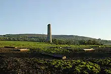
Mining landscape south from Luckett
In the 12th century, Luckett became part of a royal deer park called Kerrybullock, until it was disparked by Henry VIII in the early 16th century.[2]
South of the hamlet is Greenscoombe Wood, Luckett SSSI (Site of Special Scientific Interest), noted for its biological interest.[3]
References
- Ordnance Survey: Landranger map sheet 201 Plymouth & Launceston ISBN 978-0-319-23146-3
- North Cornwall District Council, "Luckett: Conservation Area Character Statement" (PDF), Cornwall.gov.uk, p. 3
- "Greenscoombe Wood, Luckett" (PDF). Natural England. 1986. Retrieved 1 November 2011.
This article is issued from Wikipedia. The text is licensed under Creative Commons - Attribution - Sharealike. Additional terms may apply for the media files.