Macherla
Macherla is a town in Guntur district of the Indian state of Andhra Pradesh. It is the headquarters of Macherla mandal in Gurazala revenue division.[3]
Macherla | |
|---|---|
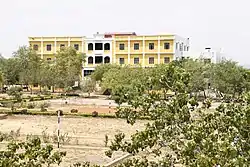
 Newton's Institute Of Science & Technology in Macherla | |
.svg.png.webp) Macherla Location in Andhra Pradesh, India | |
| Coordinates: 16.48°N 79.43°E | |
| Country | |
| State | Andhra Pradesh |
| District | Guntur |
| Founded | 2nd century |
| Incorporated (town) | 1983 |
| Government | |
| • Type | Municipal council |
| • Body | Macherla Municipality |
| • Chairperson | Nelluri Mangamma (Telugu Desam Party) |
| Area | |
| • Total | 13.48 km2 (5.20 sq mi) |
| Elevation | 136 m (446 ft) |
| Population | |
| • Total | 106,289 |
| • Density | 7,900/km2 (20,000/sq mi) |
| Languages | |
| • Official | Telugu |
| Time zone | UTC+5:30 (IST) |
| PIN | 522426 |
| Telephone code | 08642 |
| Website | macherla |
History
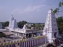
Macherla is capital of the region Palnadu. The name Macherla originated from Mahadevi Cherla. This town is in the heart of Palnadu, and has a history of over a thousand years. The famous battle Palnati Yudhdham (War of Palnadu) took place between Macherla and Gurajala between 1176 AD – 1182 AD. The Palnadu Battle is also called the Andhra Mahabharatam because of several similarities. The town is renowned for the Chennakesava Swamy temple built here during the reign of the Haihaya Kings. Palanati Brahmanaidu is the minister to Haihaya kings, who tried to abolish the caste system by "Chapa Koodu" or "Sahapankthi Bhojanalu" in the 12th century.
Geography
Macherla is located at 16.48°N 79.43°E.[4] It has an average elevation of 136 metres (446 feet). It is located 23 kilometers from Nagarjuna Sagar. Jerri Vagu is the source of water for the town and the surrounding villages.[5]
Demographics
As of 2011 census of India, the city had a population of 1,06,289. The average literacy rate stands at 71.13% with 86,176 literates, significantly higher than the state average of 67.41%.[1][6]
Governance and politics
Civic administration
Macherla Municipality is the civic body of the town and constituted in the year 1983.[7] The municipality is classified as second grade and has a jurisdictional area of the municipality is present area of the corporation is 32.94 km2 (12.72 sq mi).[8] Nelluri Mangamma is the present chairman of the municipality.[9]
Culture and tourism

Nagarjunakonda Museum Nagarjunakonda, meaning the hill of Nagarjuna, was named after the Buddhist scholar and savant Acharya Nagarjuna. It was a great religious centre promoting Brahmanism and Buddhist faiths, moulding the early phases of art and architecture affiliated with them. The Ethipothala Falls lies 8 km from Macherla, is a mountain stream cascading down the hills as Chandravanka and Suryavanka streams. The Suryavanka falls from a height of 21 meters into a lagoon and joins River Krishna.[10] The Sri Lakshmi Chennakesava swami temple hosts a yearly local festival, Tirunalla.
Transport
The town has a total road length of 76.23 km (47.37 mi).[11]
Education
As per the school information report for the academic year 2018–19, the village has a total of 21 schools. These include 1 MPP, 1 KGBV and 19 private schools.[12]
See also
References
- "District Census Handbook – Guntur" (PDF). Census of India. p. 46. Retrieved 18 January 2015.
- "Census 2011". The Registrar General & Census Commissioner, India. Retrieved 25 July 2014.
- "New Gurazala revenue division created". The Hindu. Gurazala (Guntur District). 1 July 2013. Retrieved 17 January 2015.
- "Maps, Weather, and Airports for Macherla, India". fallingrain.com.
- "With summer setting in, water crisis hits Guntur mandals hard". The New Indian Express. Guntur. 15 April 2019. Retrieved 25 May 2019.
- "Literacy of AP (Census 2011)" (PDF). Official Portal of Andhra Pradesh Government. p. 43. Archived from the original (PDF) on 14 July 2014. Retrieved 5 September 2014.
- "Municipalities, Municipal Corporations & UDAs" (PDF). Directorate of Town and Country Planning. Government of Andhra Pradesh. Archived from the original (PDF) on 8 August 2016. Retrieved 23 June 2016.
- "Municipality Profile". macherla.cdma.ap.gov.in. Retrieved 9 May 2017.
- "Ward Profile". macherla.cdma.ap.gov.in. Retrieved 9 May 2017.
- "Ethipothala" (PDF). Census of India. p. 7. Retrieved 18 January 2015.
- "Details of Roads in Each ULB of Andhra Pradesh". Commissioner and Directorate of Municipal Administration. Municipal Administration and Urban Development Department – Government of Andhra Pradesh. Archived from the original on 1 August 2016. Retrieved 28 March 2017.
- "School Information". Commissionerate of School Education. Government of Andhra Pradesh. Retrieved 7 May 2019.