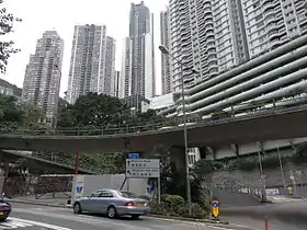
Magazine Gap Road
Magazine Gap Road is a winding road on the affluent and ultra-expensive Mid-Levels and the Peak on the Hong Kong Island in Hong Kong. It is one of the main access leading to the Peak area.
 Western terminus of Magazine Gap Road in Mid-Levels, Hong Kong | |
| Native name | 馬己仙峽道 (Chinese) |
|---|---|
| Maintained by | Highways Department |
| Length | 1.8 km[1] (1.1 mi) |
| Location | Mid-Levels |
| East end | Peak Road |
| West end | Robinson Road / Garden Road |
| Magazine Gap Road | |||||||||||||
|---|---|---|---|---|---|---|---|---|---|---|---|---|---|
| Traditional Chinese | 馬己仙峽道 | ||||||||||||
| Simplified Chinese | 马己仙峡道 | ||||||||||||
| |||||||||||||
Description
It starts low from Robinson Road and Garden Road. It runs east and uphill and meets Bowen Road and May Road. It continues and meets the junction with Coombe Road and Peak Road at Magazine Gap. It ends in a peak nearby.
With road connections nearby, vehicles can reach either north or south of the island through roads in Wan Chai Gap and Wong Nai Chung Gap.
Intersections
The entire road is in Central and Western District.
| Location | km[1] | mi | Destinations | Notes | |
|---|---|---|---|---|---|
| Magazine Gap | 0.0 | 0.0 | Peak Road | ||
| Mid-Levels | 1.1 | 0.68 | May Road | ||
| 1.6 | 0.99 | Bowen Road | |||
| 1.7 | 1.1 | Brewin Path | |||
| 1.8 | 1.1 | Robinson Road / Garden Road | |||
| 1.000 mi = 1.609 km; 1.000 km = 0.621 mi | |||||
References
| Wikimedia Commons has media related to Magazine Gap Road. |
- OpenStreetMap contributors. Magazine Gap Road (Map). OpenStreetMap. Retrieved 20 March 2016.
This article is issued from Wikipedia. The text is licensed under Creative Commons - Attribution - Sharealike. Additional terms may apply for the media files.