Marakkanam
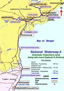
Marakkanam is a coastal panchayat town & Taluk in Viluppuram district in the Indian state of Tamil Nadu. It is well connected to the state capital Chennai and the nearby union territory of Puducherry by the East Coast Road. To the west, Marakkanam is connected to the town of Tindivanam by the SH-134. Marakkanam is situated on the declared National Waterways NW-4. On materialisation of National Waterways NW-4, Marakkanam will be connected to two states Andhra Pradesh (Kakinada) and Puducherry through north and south of Buckingham Canal.

Marakkanam | |
|---|---|
city | |
 Marakkanam Location in Tamil Nadu, India | |
| Coordinates: 12.2°N 79.95°E | |
| Country | |
| State | Tamil Nadu |
| District | Viluppuram |
| Elevation | 14 m (46 ft) |
| Population (2001) | |
| • Total | 19,153 |
| Languages | |
| • Official | Tamil |
| Time zone | UTC+5:30 (IST) |
| Vehicle registration | TN-16 |
History
Marakkanam was connected to Vijayawada in Andhra Pradesh through the Buckingham Canal, a 420 km long fresh water navigation canal. The 110-km stretch from Marakkanam to Chennai is called South Buckingham Canal. The canal connects most of the natural backwaters along the coast to the port of Chennai (Madras). It was constructed by the British Raj, and was an important waterway during the late nineteenth and the twentieth century.Canal was formerly used to convey goods up and down, but later the usage has downgraded due to industrial pollution of water.

Geography
Indian Postal code for Marakkanam is 604303.
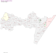
Marakkanam panchayat town was divided into 56 Village Panchayats.The following are the Village Panchayats under Marakkanam
|
|
|
|
Demographics
As of 2001 India census,[1] Marakkanam had a population of 19,153. Males constitute 50% of the population and females 50%. Marakkanam has an average literacy rate of 61%, higher than the national average of 59.5%: male literacy is 70%, and female literacy is 52%. In Marakkanam, 13% of the population is under 6 years of age.
Major resources

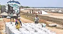
- Salt Production (Largest Salt Production Happening Next to Tuticorin in every year)
- Fishing
- Agriculture
- Real Estate
Temples
- Arulmigu Boomieshwarar Temple (which was Built 1000 years back by Chola dynasty kings)
- Arulmigu Varadharaja Perumal Temple (which was also Built 1000 years back by Chola dynasty kings)
- Arulmigu Thropadhi amman Temple (25 days Festival Happening every year in the Month of MAY and JUNE)
- Aadavaliswar temple in Munnur village (Temple was built by Chola king 2nd kulothunga Chola)
Masjids
- Jamia Masjid, Salt Road (Masjid Street)
- Thazhan Kadu Masjid
- Chetti Nagar Masjid
- Seiyyankuppam Masjid
- Koonimedu Masjid
- Firdaws Nagar Masjid (Koonimedu)
Churches
- Our Lady of Immaculate church in Munnur village, which was built by Fr. Clement who belongs to MEP. Church was built on 1907.
- Church of Our Lady Maduranayagy, Marakkanam (Roman Catholic)
- Lord Jesus Christ's Prayer House, Thenpakkam (pentecost)
- Lord Jesus Christ's Prayer House, Nadukuppam (Pentecost)
- A.G Church, Marakkanam
- Christ Church, Marakkanam (C.S.I)
Schools
- Government Higher Secondary School
- Government Girls High School
- Sri Ramakrishna Matriculation School
- St.Joseph's Primary School (R.C.Primary School)
- Panchayat Union Elementary School
- ALM Matriculation School
- J.M.J. Matriculation and Higher l Secondary School
- Good shepherd primary school
- chanakiya vidhyasharam cbsc school
Hospitals
Government Hospital, Marakkanam (Near ECR bypass)
Road Connectivity
- 34 km from Tindivanam. It is well connected to the Tindivanam.
- All the buses plying through ECR via Kovalam, Mamallapuram, Kadapakkam Chennai to Pondicherry are connected to Marakkanam.
- Connected to Chennai and Pondicherry with government bus No 83A via Chengalpattu, Madhuranthagam, Soonambedu,Asappur, Allathur
- Connected to Chennai and Marakkanam with government bus No 188A via Kovalam, Mamallapuram, Kalpakkam, Kadapakkam
- Connected to Chennai and Cuddalore with government bus No 162 via Chengalpattu, Madhuranthagam, Soonambedu, Allathur
Places near Marakkanam
Vennangupattu
- Ekkiyarkuppam
- Anumandai
- Koonimedu
- Murukkery
- Munnur
- Brahmadesam
- Nagar-5 km from Murukkery towards North
- Nallalam
- Soonambedu
- Kadapakkam
- Alamparai Fort
- Vadanerkunam
- Alankuppam
See also
References
- "Census of India 2001: Data from the 2001 Census, including cities, villages and towns (Provisional)". Census Commission of India. Archived from the original on 16 June 2004. Retrieved 1 November 2008.
External links
| Wikimedia Commons has media related to Marakkanam. |
