Mologa (river)
The Mologa (Russian: Молога) is a river in Maksatikhinsky, Bezhetsky, Lesnoy, and Sandovsky Districts of Tver Oblast, Pestovsky District in Novgorod Oblast, and Ustyuzhensky and Cherepovetsky Districts in Vologda Oblast Russia. It is a left tributary of the Volga. The lower course of the Mologa has been turned into the Rybinsk Reservoir. It is 456 kilometres (283 mi) long, and the area of its basin 29,700 square kilometres (11,500 sq mi).[2] The principal tributaries of the Mologa are the Osen (right), the Volchina (left), the Kobozha (left), the Chagodoshcha (left) and the Sit (right, now it is a tributary of the Rybinsk Reservoir).
| Mologa | |
|---|---|
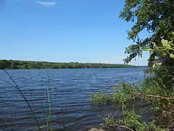
 The lower course of the Mologa | |
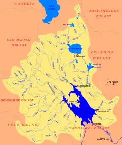
 Map of the Rybinsk Reservoir basin. The Mologa is shown on the map | |
| Native name | Молога |
| Location | |
| Country | Russia |
| Physical characteristics | |
| Source | |
| • location | Valdai Hills |
| Mouth | Volga |
• location | Rybinsk Reservoir |
• coordinates | 58°52′59″N 37°4′48″E |
• elevation | 101 m (331 ft) |
| Length | 456 km (283 mi)[1] |
| Basin size | 29,700 km2 (11,500 sq mi)[1] |
| Discharge | |
| • average | 237 m3/s (8,400 cu ft/s)[1] |
| Basin features | |
| Progression | Volga→ Caspian Sea |
The towns of Bezhetsk, Pestovo, and Ustyuzhna, and the urban-type settlement of Maksatikha are on the banks of the Mologa River. A historic town of Mologa used to stand at the confluence of the Mologa river with the Volga, but it was submerged under water as the Rybinsk Reservoir was filled between 1939 and 1947. The town of Vesyegonsk was also previously on the banks of the Mologa, however, it was relocated when the Rybinsk Reservoir was filled, and is on the banks of the reservoir.
The source of the Mologa is in the southeastern part of Maksatikhinsky District, in the eastern outskirts of Valdai Hills. The river flows east, enters Bezhetsky District, turns north, flows through the town of Bezhetsk, and flows into Lake Verestovo. It flows out of the lake in the western direction, reenters Maksatikhinsky District, flows through the urban-type settlement of Maksatikha and turns north. A stretch of the Mologa forms the border between Maksatikhinsky and Lesnoy Districts. The river crosses over to Lesnoy District, crosses it, flows at the border between Lesnoy and Sandovsky District and crosses into Novgorod Oblast. Downstream of the town of Pestovo the Mologa turns northeast and enters Vologda Oblast. There, it flows through the town of Ustyuzhna, accepts from the left the Kobozha and the Chagodoshcha, sharply turns southeast and flows into the Rybinsk Reservoir.
The river basin of the Mologa comprises vast areas in the north of Tver Oblast, in the east of Novgorod Oblast, in the southeast of Leningrad Oblast (Boksitogorsky District), as well as the southeast of Vologda Oblast.
The lower course of the Mologa, downstream of the mouth of the Chagodoshcha, belongs to Tikhvinskaya water system, one of the waterways constructed in the early 19th century to connect the river basins of the Volga and the Neva. Currently, it is not used for any commercial navigation.[3]
Until the 1990s, the Mologa was used for timber rafting. The timber collecting facilities were in Pestovo.[4]
The river freezes up in late October through early December and stays under the ice until April or early May.[1]
References
- Молога (река). Great Soviet Encyclopedia.
- «Река Молога», Russian State Water Registry
- Хрусталев, М. Ю. (1999). По Тихвинской водной системе. Из истории водных коммуникаций и судоходства. Чагода: Историко-краеведческий альманах (in Russian). Vologda: Ардвисура. Retrieved 17 November 2012.
- Плечко, Л.А.; Сабанеева, И.П. (1973). Водные маршруты СССР. Европейская часть (in Russian). Moscow: Физкультура и спорт.
External links
| Wikimedia Commons has media related to Mologa River. |
- Река Молога (in Russian). State Water Register of Russia. Retrieved 27 March 2014.
