Montauville
Montauville is a commune in the Meurthe-et-Moselle department in north-eastern France.
Montauville | |
|---|---|
 The church in Montauville | |
 Coat of arms | |
Location of Montauville 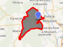
| |
 Montauville  Montauville | |
| Coordinates: 48°54′06″N 6°01′18″E | |
| Country | France |
| Region | Grand Est |
| Department | Meurthe-et-Moselle |
| Arrondissement | Nancy |
| Canton | Pont-à-Mousson |
| Intercommunality | CC Bassin de Pont-à-Mousson |
| Government | |
| • Mayor (2008–2014) | Pascal Fleury |
| Area 1 | 16.19 km2 (6.25 sq mi) |
| Population (2017-01-01)[1] | 1,056 |
| • Density | 65/km2 (170/sq mi) |
| Time zone | UTC+01:00 (CET) |
| • Summer (DST) | UTC+02:00 (CEST) |
| INSEE/Postal code | 54375 /54700 |
| Elevation | 193–376 m (633–1,234 ft) (avg. 219 m or 719 ft) |
| 1 French Land Register data, which excludes lakes, ponds, glaciers > 1 km2 (0.386 sq mi or 247 acres) and river estuaries. | |
It is the location of the French Le Pétant military cemetery, with WWI casualties of the Battle of Bois-le-Prêtre, and French WWII soldiers which died in German captivity.
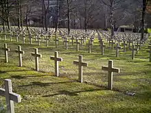
French Le Pétant cemetery (Montauville)
References
- "Populations légales 2017". INSEE. Retrieved 6 January 2020.
| Wikimedia Commons has media related to Montauville. |
| Authority control |
|
|---|
This article is issued from Wikipedia. The text is licensed under Creative Commons - Attribution - Sharealike. Additional terms may apply for the media files.