Montpont-en-Bresse
Montpont-en-Bresse is a commune in the Saône-et-Loire department in the region of Bourgogne-Franche-Comté in eastern France.
Montpont-en-Bresse | |
|---|---|
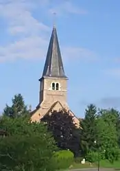 The church in Montpont-en-Bresse | |
 Coat of arms | |
Location of Montpont-en-Bresse 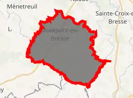
| |
 Montpont-en-Bresse  Montpont-en-Bresse | |
| Coordinates: 46°33′29″N 5°09′54″E | |
| Country | France |
| Region | Bourgogne-Franche-Comté |
| Department | Saône-et-Loire |
| Arrondissement | Louhans |
| Canton | Cuiseaux |
| Intercommunality | Communauté de communes Terres de Bresse |
| Government | |
| • Mayor (2014–2020) | Michel Puget |
| Area 1 | 37.46 km2 (14.46 sq mi) |
| Population (2017-01-01)[1] | 1,099 |
| • Density | 29/km2 (76/sq mi) |
| Time zone | UTC+01:00 (CET) |
| • Summer (DST) | UTC+02:00 (CEST) |
| INSEE/Postal code | 71318 /71470 |
| Elevation | 182–213 m (597–699 ft) (avg. 198 m or 650 ft) |
| 1 French Land Register data, which excludes lakes, ponds, glaciers > 1 km2 (0.386 sq mi or 247 acres) and river estuaries. | |
Geography
The Sâne Morte forms the commune's south-eastern border. The Sâne Vive flows northwestward through the middle of the commune.
References
- "Populations légales 2017". INSEE. Retrieved 6 January 2020.
| Wikimedia Commons has media related to Montpont-en-Bresse. |
| Authority control |
|
|---|
This article is issued from Wikipedia. The text is licensed under Creative Commons - Attribution - Sharealike. Additional terms may apply for the media files.