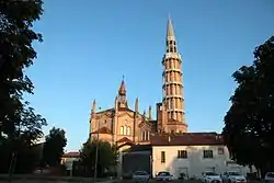
Mortegliano
Mortegliano (Friulian: Mortean) is a comune (municipality) in the Italian region Friuli-Venezia Giulia, located about 60 km northwest of Trieste and about 14 km southwest of Udine.
Mortegliano | |
|---|---|
| Comune di Mortegliano | |
 Mortegliano Cathedral | |
Location of Mortegliano 
| |
 Mortegliano Location of Mortegliano in Italy  Mortegliano Mortegliano (Friuli-Venezia Giulia) | |
| Coordinates: 45°57′N 13°10′E | |
| Country | Italy |
| Region | Friuli-Venezia Giulia |
| Frazioni | Chiasiellis, Lavariano |
| Government | |
| • Mayor | Roberto Zuliani |
| Area | |
| • Total | 30.05 km2 (11.60 sq mi) |
| Elevation | 41 m (135 ft) |
| Population (30 April 2017)[2] | |
| • Total | 4,967 |
| • Density | 170/km2 (430/sq mi) |
| Demonym(s) | Morteglianesi |
| Time zone | UTC+1 (CET) |
| • Summer (DST) | UTC+2 (CEST) |
| Postal code | 33050 |
| Dialing code | 0432 |
| Website | Official website |
Mortegliano borders the following municipalities: Bicinicco, Castions di Strada, Lestizza, Pavia di Udine, Pozzuolo del Friuli, Talmassons.
The tallest campanile, or free-standing bell tower, in the world at 113.2 metres (371 ft) high, is the Mortegliano Bell Tower.[3][4]
References
- "Superficie di Comuni Province e Regioni italiane al 9 ottobre 2011". Istat. Retrieved 16 March 2019.
- All demographics and other statistics: Italian statistical institute Istat.
- "25 tallest clock towers/government structures/palaces" (PDF). Council on Tall Buildings and Urban Habitat. January 2008. Archived from the original (PDF) on 2008-10-30. Retrieved 2008-08-09.
- "Campus tour booklet" (PDF). University of Birmingham. Retrieved 2008-08-09.
This article is issued from Wikipedia. The text is licensed under Creative Commons - Attribution - Sharealike. Additional terms may apply for the media files.
