Muttama, New South Wales
Muttama is a rural community in the central east part of the Riverina. It is situated by road, about 24 kilometres south of Cootamundra and 17 kilometres north of Coolac.
| Muttama New South Wales | |||||||||||||||
|---|---|---|---|---|---|---|---|---|---|---|---|---|---|---|---|
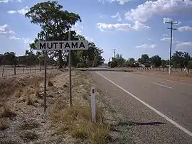 Entering Muttama | |||||||||||||||
Muttama | |||||||||||||||
| Coordinates | 34°48′10″S 148°07′01″E | ||||||||||||||
| Postcode(s) | 2722 | ||||||||||||||
| Elevation | 357 m (1,171 ft) | ||||||||||||||
| Location |
| ||||||||||||||
| LGA(s) | Cootamundra-Gundagai Regional Council | ||||||||||||||
| County | Harden | ||||||||||||||
| State electorate(s) | Cootamundra | ||||||||||||||
| Federal Division(s) | |||||||||||||||
| |||||||||||||||
The name Muttama is derived from the local Aboriginal word meaning "like it" or "take it".[1]
Mining in the area began in the 1860s and Muttama prospered with the discovery of gold at Muttama Reef in 1882.[2] Muttama Reef Post Office opened on 1 February 1876, was renamed Muttama in 1889, and closed on 12 October 1979.[3] The village was served by a railway station on the Tumut branch from 1886-1975, when passenger services were discontinued. All goods traffic on line was suspended after flooding in 1984.[4]
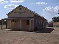 Muttama Hall
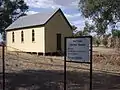 Muttama Uniting Church
References
- "Muttama". Geographical Names Register (GNR) of NSW. Geographical Names Board of New South Wales.

- "THE MUTTAMA REEF GOLD RUSH". The Australasian. XXII (823). Victoria, Australia. 7 January 1882. p. 21 – via National Library of Australia.
- Premier Postal History, Post Office List, retrieved 21 February 2011
- "Tumut Branch". www.nswrail.net. Retrieved 5 August 2014.
External links
![]() Media related to Muttama, New South Wales at Wikimedia Commons
Media related to Muttama, New South Wales at Wikimedia Commons
This article is issued from Wikipedia. The text is licensed under Creative Commons - Attribution - Sharealike. Additional terms may apply for the media files.