Nabha State
Nabha State,[1] with its capital at Nabha, was one of the Phulkian princely states of Punjab during the British Raj in India.[2]
| Nabha State | |||||||||
|---|---|---|---|---|---|---|---|---|---|
| Princely State | |||||||||
| 1763–1947 | |||||||||
 Flag
 Coat of arms
| |||||||||
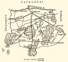 Nabha State in a 1911 map of Ludhiana district | |||||||||
| Area | |||||||||
• 1901 | 2,502 km2 (966 sq mi) | ||||||||
| Population | |||||||||
• 1901 | 297,949 | ||||||||
| Historical era | New Imperialism | ||||||||
• Established | 1763 | ||||||||
• Accession to India | 1947 | ||||||||
| |||||||||
| Today part of | |||||||||
_(14597378638).jpg.webp)
Sir Hira Singh, Raja of Nabha (c.1843-1911).
Demography
According to the 1901 census the state had a population of 297,949 and contained four towns and 488 villages. Its population at the previous two enumerations were: 282,756 (1891) and 261,824(1881).
Nabha was divided into three nizamats: Amloh and Bawal, with their headquarters at the town from which each is named; and Phul, with its headquarters at Dhanaula.[3]
More than 54 per cent of the population were Hindus, only 26 per cent being Sikhs — although Nabha was one of the principal Sikh states of the Punjab, the remainder of the population were Muslim.[4]
References
- Imperial Gazetteer of India, v. 18, p. 271.
- Chisholm, Hugh, ed. (1911). . Encyclopædia Britannica. 19 (11th ed.). Cambridge University Press. p. 147.
- Nābha State - Imperial Gazetteer of India, v. 18, p. 264.
- Nābha State - Imperial Gazetteer of India, v. 18, p. 265.
External links
 Media related to Nabha State at Wikimedia Commons
This article is issued from Wikipedia. The text is licensed under Creative Commons - Attribution - Sharealike. Additional terms may apply for the media files.