National Register of Historic Places listings in Amite County, Mississippi
This is a list of the National Register of Historic Places listings in Amite County, Mississippi.
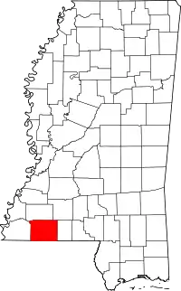
Location of Amite County in Mississippi
This is intended to be a complete list of the properties on the National Register of Historic Places in Amite County, Mississippi, United States. Latitude and longitude coordinates are provided for many National Register properties; these locations may be seen together in a map.[1]
There are 19 properties listed on the National Register in the county. Another property was once listed but has been removed.
- This National Park Service list is complete through NPS recent listings posted February 5, 2021.[2]
Current listings
| [3] | Name on the Register[4] | Image | Date listed[5] | Location | City or town | Description |
|---|---|---|---|---|---|---|
| 1 | Amite County Courthouse |  Amite County Courthouse |
April 9, 1974 (#74001055) |
Main St. 31°09′27″N 90°48′38″W |
Liberty | |
| 2 | Amite Female Seminary |  Amite Female Seminary |
April 17, 1980 (#80002200) |
Mississippi Highway 569 31°09′37″N 90°48′20″W |
Liberty | |
| 3 | Thomas Batchelor House | March 27, 1975 (#75001040) |
5 miles east of Liberty of Olio Rd. 31°02′31″N 90°52′53″W |
Liberty | ||
| 4 | Bethany Institute | August 3, 1978 (#78001588) |
East of Centreville on Mississippi Highway 48 31°05′52″N 90°59′19″W |
Centreville | ||
| 5 | Bethany Presbyterian Church | June 23, 2003 (#03000553) |
Junction of Mississippi Highway 48 and Perry Rd. 31°06′07″N 90°59′11″W |
Centreville | ||
| 6 | Decatur N. Butler House | May 1, 1984 (#84002113) |
Off Mississippi Highway 567 31°11′46″N 90°49′54″W |
Liberty | ||
| 7 | Felder-Richmond House | July 12, 1984 (#84002115) |
Off Interstate 55 31°08′45″N 90°35′34″W |
Magnolia | ||
| 8 | Hampton Lea House | July 12, 1984 (#84002120) |
Lea Rd. 31°06′18″N 90°36′24″W |
Magnolia | ||
| 9 | Wilford Zachariah Lea House | 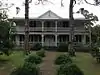 Wilford Zachariah Lea House |
October 25, 1995 (#95001181) |
Mississippi Highway 569, N., 2 miles north of Liberty 31°10′48″N 90°46′47″W |
Liberty | |
| 10 | Liberty Presbyterian Church |  Liberty Presbyterian Church |
May 16, 1985 (#85001075) |
North Church St. 31°09′31″N 90°48′33″W |
Liberty | |
| 11 | McGehee House | November 25, 1983 (#83003939) |
Southeast of Zion Hill 31°15′04″N 90°47′55″W |
Liberty | ||
| 12 | Theodore L. McGehee Plantation House | March 1, 1996 (#96000189) |
5924 Tangipahoa Rd. 31°18′38″N 90°34′20″W |
Summit | ||
| 13 | Pinewood | July 5, 1984 (#84002122) |
South of Liberty off Greensburg Rd. 31°02′14″N 90°48′20″W |
Liberty | ||
| 14 | Sherman Line Rosenwald School | January 12, 2017 (#100000535) |
3021 Sherman Church Rd. 31°08′54″N 90°33′04″W |
Magnolia | ||
| 15 | Sturdivant Fishweir | April 14, 1978 (#78001589) |
Address Restricted |
Rosetta | ||
| 16 | Sunnyslope | March 22, 1982 (#82003096) |
Northeast of Centreville 31°06′48″N 91°02′25″W |
Centreville | ||
| 17 | George Webb House | November 17, 1983 (#83003940) |
East of Old Zion Hill Rd. 31°11′04″N 90°49′31″W |
Liberty | ||
| 18 | Westbrook Cotton Gin | 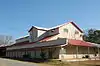 Westbrook Cotton Gin |
November 10, 2010 (#10000903) |
395 Gillsburg Rd. 31°09′22″N 90°48′27″W |
Liberty | |
| 19 | Winston Wilkinson House |  Winston Wilkinson House |
April 17, 1980 (#80002201) |
North of Liberty on Mississippi Highway 567 31°16′22″N 90°51′02″W |
Liberty |
Former listing
| [3] | Name on the Register | Image | Date listed | Date removed | Location | City or town | Summary |
|---|---|---|---|---|---|---|---|
| 1 | Talbert-Cassels House | March 1, 1984 (#84002125) | July 16, 2008 | Off Mississippi Highway 574 |
Gloster vicinity | Destroyed by fire December 2006 [6] |
See also
| Wikimedia Commons has media related to National Register of Historic Places in Amite County, Mississippi. |
References
- The latitude and longitude information provided in this table was derived originally from the National Register Information System, which has been found to be fairly accurate for about 99% of listings. Some locations in this table may have been corrected to current GPS standards.
- "National Register of Historic Places: Weekly List Actions". National Park Service, United States Department of the Interior. Retrieved on February 5, 2021.
- Numbers represent an alphabetical ordering by significant words. Various colorings, defined here, differentiate National Historic Landmarks and historic districts from other NRHP buildings, structures, sites or objects.
- "National Register Information System". National Register of Historic Places. National Park Service. March 13, 2009.
- The eight-digit number below each date is the number assigned to each location in the National Register Information System database, which can be viewed by clicking the number.
- MDAH
| Topics | |
|---|---|
| Lists by state |
|
| Lists by insular areas | |
| Lists by associated state | |
| Other areas | |
| Related | |
| |
Municipalities and communities of Amite County, Mississippi, United States | ||
|---|---|---|
| Towns | Map of Mississippi highlighting Amite County | |
| Unincorporated communities | ||
| Ghost town | ||
| Footnotes | ‡This populated place also has portions in an adjacent county or counties | |
| ||
This article is issued from Wikipedia. The text is licensed under Creative Commons - Attribution - Sharealike. Additional terms may apply for the media files.