National Register of Historic Places listings in Caldwell Parish, Louisiana
This is a list of the National Register of Historic Places listings in Caldwell Parish, Louisiana.
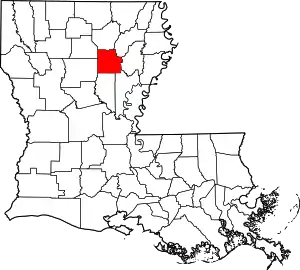
Location of Caldwell Parish in Louisiana
This is intended to be a complete list of the properties on the National Register of Historic Places in Caldwell Parish, Louisiana, United States. The locations of National Register properties for which the latitude and longitude coordinates are included below, may be seen in a map.[1]
There are 9 properties listed on the National Register in the parish.
- This National Park Service list is complete through NPS recent listings posted February 5, 2021.[2]
Current listings
| [3] | Name on the Register | Image | Date listed[4] | Location | City or town | Description |
|---|---|---|---|---|---|---|
| 1 | Blanks House | January 17, 1995 (#94001567) |
201 Wall Street 32°06′14″N 92°04′26″W |
Columbia | ||
| 2 | Breston Plantation House | November 22, 1980 (#80001709) |
About 5 miles (8.0 km) northwest of Columbia on east bank of Riverton Lake 32°10′13″N 92°05′53″W |
Columbia | ||
| 3 | Downtown Columbia Historic District | 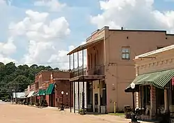 Downtown Columbia Historic District |
October 18, 1996 (#96001164) |
Junction of Main Street and Pearl Street 32°06′21″N 92°04′29″W |
Columbia | The 3 acres (1.2 ha) area comprises a total of 16 contributing properties, built between 1909 and 1930s.[5] |
| 4 | First United Methodist Church | 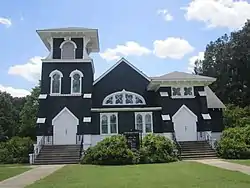 First United Methodist Church |
August 12, 1982 (#82002764) |
501 Church Street 32°06′17″N 92°04′39″W |
Columbia | |
| 5 | Landerneau Mound | January 14, 1999 (#98001579) |
Address restricted[6] |
Hebert | ||
| 6 | Martin House | August 12, 1993 (#93000832) |
203 Martin Place Road 32°07′29″N 92°04′05″W |
Columbia | Now hosting the Martin Home Place Museum. | |
| 7 | The Oasis | July 31, 1989 (#89000976) |
1710 Main Street (LA 845) 32°01′36″N 92°08′22″W |
Clarks | Now hosting the Clarks Post Office. | |
| 8 | Schepis Building |  Schepis Building |
January 16, 1986 (#86000069) |
Main Street 32°06′23″N 92°04′28″W |
Columbia | Also part of Downtown Columbia Historic District since its creation on October 18, 1996.[5] |
| 9 | Synope Plantation House |  Synope Plantation House |
October 5, 1982 (#82000432) |
On Synope Road, along Ouachita River levee, about 600 yards (550 m) south of U.S. Route 165 32°11′37″N 92°06′49″W |
Columbia |
See also
| Wikimedia Commons has media related to National Register of Historic Places in Caldwell Parish, Louisiana. |
References
- The latitude and longitude information provided in this table was derived originally from the National Register Information System, which has been found to be fairly accurate for about 99% of listings. Some locations in this table may have been corrected to current GPS standards.
- "National Register of Historic Places: Weekly List Actions". National Park Service, United States Department of the Interior. Retrieved on February 5, 2021.
- Numbers represent an alphabetical ordering by significant words. Various colorings, defined here, differentiate National Historic Landmarks and historic districts from other NRHP buildings, structures, sites or objects.
- The eight-digit number below each date is the number assigned to each location in the National Register Information System database, which can be viewed by clicking the number.
- "Downtown Columbia Historic District" (PDF). State of Louisiana's Division of Historic Preservation. with a photo and three maps
- Federal and state laws and practices restrict general public access to information regarding the specific location of this resource. In some cases, this is to protect archeological sites from vandalism, while in other cases it is restricted at the request of the owner. See: Knoerl, John; Miller, Diane; Shrimpton, Rebecca H. (1990), Guidelines for Restricting Information about Historic and Prehistoric Resources, National Register Bulletin, National Park Service, U.S. Department of the Interior, OCLC 20706997.
Municipalities and communities of Caldwell Parish, Louisiana, United States | ||
|---|---|---|
| Town | | |
| Villages | ||
| CDP | ||
| Other unincorporated communities | ||
| ||
This article is issued from Wikipedia. The text is licensed under Creative Commons - Attribution - Sharealike. Additional terms may apply for the media files.