National Register of Historic Places listings in Cedar County, Nebraska
This is a list of the National Register of Historic Places listings in Cedar County, Nebraska.
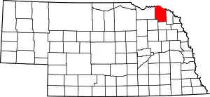
Location of Cedar County in Nebraska
This is intended to be a complete list of the properties and districts on the National Register of Historic Places in Cedar County, Nebraska, United States. The locations of National Register properties and districts for which the latitude and longitude coordinates are included below, may be seen in a map.[1]
There are 14 properties and districts listed on the National Register in the county. One property was once listed on the register, but has since been removed.
- This National Park Service list is complete through NPS recent listings posted January 29, 2021.[2]
Current listings
| [3] | Name on the Register | Image | Date listed[4] | Location | City or town | Description |
|---|---|---|---|---|---|---|
| 1 | Cedar County Courthouse | 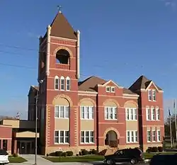 Cedar County Courthouse |
January 10, 1990 (#89002214) |
Broadway Ave. between Centre and Franklin Sts. 42°37′12″N 97°15′50″W |
Hartington | |
| 2 | City Hall and Auditorium |  City Hall and Auditorium |
July 21, 1983 (#83001080) |
101 N. Broadway 42°37′15″N 97°15′49″W |
Hartington | A Prairie School multi-use municipal building designed by William L. Steele. |
| 3 | Couser Barn | 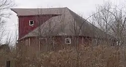 Couser Barn |
July 17, 1986 (#86001714) |
Address Restricted |
Laurel | |
| 4 | Hartington Carnegie Library | June 27, 2019 (#100004137) |
106 S. Broadway Ave. 42°37′12″N 97°15′53″W |
Hartington | ||
| 5 | Hartington Downtown Historic District | July 1, 2019 (#100004136) |
Broadway Ave. from Centre St. to Railroad St.; Main St. From Madison Ave. to Alley W of Broadway Ave. 42°37′21″N 97°15′53″W |
Hartington | ||
| 6 | Hartington Hotel | 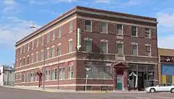 Hartington Hotel |
November 26, 2003 (#03001219) |
202 North Broadway 42°37′18″N 97°15′53″W |
Hartington | |
| 7 | Immaculate Conception Catholic Church and Rectory | 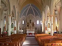 Immaculate Conception Catholic Church and Rectory |
July 5, 2001 (#01000711) |
102 and 108 E. 9th St. 42°48′33″N 97°14′52″W |
St. Helena | |
| 8 | Meridian Bridge |  Meridian Bridge |
June 17, 1993 (#93000537) |
U.S. Route 81 over the Missouri River, just south of Yankton, South Dakota 42°52′05″N 97°23′37″W |
South Yankton | Extends into Yankton County, South Dakota |
| 9 | St. Boniface Catholic Church Complex | _church_and_cemetery_from_S.JPG.webp) St. Boniface Catholic Church Complex |
July 21, 1983 (#83001081) |
Main St. 42°47′10″N 97°22′25″W |
Menominee | |
| 10 | Saints Peter and Paul Catholic Church Complex | 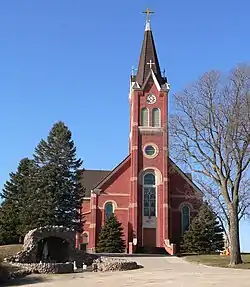 Saints Peter and Paul Catholic Church Complex |
July 5, 2000 (#00000765) |
106 W. 889th Rd. 42°42′53″N 97°15′03″W |
Bow Valley | |
| 11 | Saints Philip and James Parochial School |  Saints Philip and James Parochial School |
November 26, 2003 (#03001211) |
89039 570 Ave. 42°44′03″N 97°08′37″W |
Wynot | |
| 12 | Schulte Archeological Site | July 30, 1974 (#74001103) |
Address Restricted |
St. Helena | ||
| 13 | Wiseman Archeological Site | December 2, 1974 (#74001104) |
Address Restricted |
Wynot | ||
| 14 | Franz Zavadil Farmstead | Franz Zavadil Farmstead |
January 31, 1985 (#85000173) |
Eastern half of the southeastern quarter of Section 35, Township 33 North, Range 1 West[5] 42°47′32″N 97°23′14″W |
Menominee |
Former listings
| [3] | Name on the Register | Image | Date listed | Date removed | Location | City or town | Summary |
|---|---|---|---|---|---|---|---|
| 1 | Bow Valley Mills | 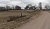 Bow Valley Mills |
November 17, 1978 (#78003402) | November 15, 2016 | North of Wynot 42°45′43″N 97°10′02″W |
Wynot | Mill building no longer at site; concrete spillway across road is still present. |
See also
References
- The latitude and longitude information provided in this table was derived originally from the National Register Information System, which has been found to be fairly accurate for about 99% of listings. Some locations in this table may have been corrected to current GPS standards.
- "National Register of Historic Places: Weekly List Actions". National Park Service, United States Department of the Interior. Retrieved on January 29, 2021.
- Numbers represent an alphabetical ordering by significant words. Various colorings, defined here, differentiate National Historic Landmarks and historic districts from other NRHP buildings, structures, sites or objects.
- The eight-digit number below each date is the number assigned to each location in the National Register Information System database, which can be viewed by clicking the number.
- Gilkerson, Joni. National Register of Historic Places Inventory/Nomination: Franz Zavadil Farmstead. National Park Service, 1984-09, 7.
External links
| Wikimedia Commons has media related to National Register of Historic Places in Cedar County, Nebraska. |
- Nebraska National Register Sites in Cedar County–Nebraska State Historical Society
| Topics | |
|---|---|
| Lists by state |
|
| Lists by insular areas | |
| Lists by associated state | |
| Other areas | |
| Related | |
| |
Municipalities and communities of Cedar County, Nebraska, United States | ||
|---|---|---|
| Cities | Map of Nebraska highlighting Cedar County | |
| Villages | ||
| CDPs | ||
| Unincorporated communities | ||
| ||
This article is issued from Wikipedia. The text is licensed under Creative Commons - Attribution - Sharealike. Additional terms may apply for the media files.