National Register of Historic Places listings in Sanilac County, Michigan
This is a list of the National Register of Historic Places listings in Sanilac County, Michigan.
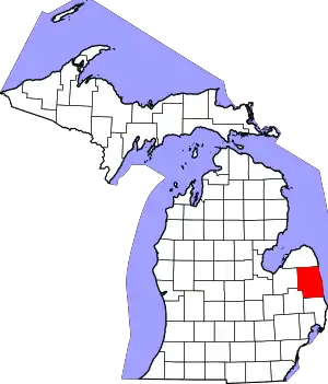
Location of Sanilac County in Michigan
This is intended to be a complete list of the properties and districts on the National Register of Historic Places in Sanilac County, Michigan, United States. Latitude and longitude coordinates are provided for many National Register properties and districts; these locations may be seen together in a map.[1]
There are 12 properties and districts listed on the National Register in the county.
- This National Park Service list is complete through NPS recent listings posted January 29, 2021.[2]
Current listings
| [3] | Name on the Register[4] | Image | Date listed[5] | Location | City or town | Description |
|---|---|---|---|---|---|---|
| 1 | Cadillac House | 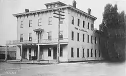 Cadillac House |
December 4, 2018 (#100003216) |
5502 Main St. 43°16′06″N 82°31′52″W |
Lexington | |
| 2 | John Divine Law Office–Moore Public Library | 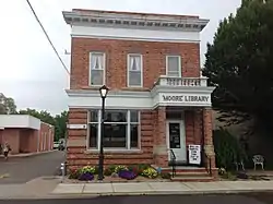 John Divine Law Office–Moore Public Library |
January 31, 1985 (#85000167) |
7239 Huron Ave. 43°16′06″N 82°31′57″W |
Lexington | |
| 3 | John L. Fead House | 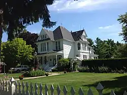 John L. Fead House |
October 5, 1978 (#78001510) |
5349 Washington St. 43°16′18″N 82°31′45″W |
Lexington | |
| 4 | Joseph M. Loop House | 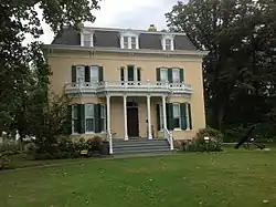 Joseph M. Loop House |
November 9, 1972 (#72000654) |
228 S. Ridge 43°25′28″N 82°32′38″W |
Port Sanilac | |
| 5 | Thomas and Margaret Spencer Matthews Farm | 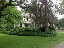 Thomas and Margaret Spencer Matthews Farm |
April 7, 1995 (#95000371) |
5916 E. Gardner Line Rd., Worth Township 43°12′28″N 82°34′48″W |
Amadore | |
| 6 | Charles H. Moore–Albert E. Sleeper House |  Charles H. Moore–Albert E. Sleeper House |
January 11, 1985 (#85000064) |
7277 Simons St. 43°16′10″N 82°31′50″W |
Lexington | |
| 7 | William Reuben Nims House | 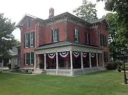 William Reuben Nims House |
April 11, 1985 (#85000719) |
7156 Huron Ave. 43°16′03″N 82°32′09″W |
Lexington | |
| 8 | Port Sanilac Light Station |  Port Sanilac Light Station |
July 19, 1984 (#84001842) |
Lake St. 43°25′44″N 82°32′24″W |
Port Sanilac | |
| 9 | Port Sanilac Masonic and Town Hall | 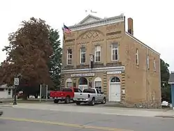 Port Sanilac Masonic and Town Hall |
July 25, 1996 (#96000808) |
20 N. Ridge St. 43°25′53″N 82°32′31″W |
Port Sanilac | |
| 10 | W.R. Roach Cannery Warehouse and Office Building | 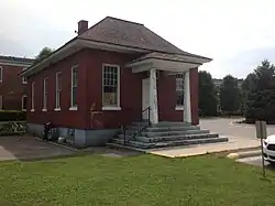 W.R. Roach Cannery Warehouse and Office Building |
July 20, 2005 (#05000717) |
89 E. Sanborn 43°16′21″N 82°36′54″W |
Croswell | |
| 11 | Sanilac Petroglyphs (ezhibiigadek asin) |
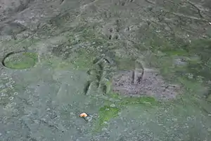 Sanilac Petroglyphs (ezhibiigadek asin) |
January 25, 1971 (#71001024) |
8251 Germania Rd.[6] 43°39′28″N 83°01′07″W |
Greenleaf Township | |
| 12 | SPORT (tug) Shipwreck Site | 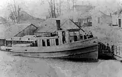 SPORT (tug) Shipwreck Site |
October 29, 1992 (#92001503) |
Three miles off the coast of Lexington[7] 43°16′00″N 82°27′54″W |
Lexington |
See also
| Wikimedia Commons has media related to National Register of Historic Places in Sanilac County, Michigan. |
References
- The latitude and longitude information provided in this table was derived originally from the National Register Information System, which has been found to be fairly accurate for about 99% of listings. Some locations in this table may have been corrected to current GPS standards.
- "National Register of Historic Places: Weekly List Actions". National Park Service, United States Department of the Interior. Retrieved on January 29, 2021.
- Numbers represent an alphabetical ordering by significant words. Various colorings, defined here, differentiate National Historic Landmarks and historic districts from other NRHP buildings, structures, sites or objects.
- "National Register Information System". National Register of Historic Places. National Park Service. April 24, 2008.
- The eight-digit number below each date is the number assigned to each location in the National Register Information System database, which can be viewed by clicking the number.
- Location derived from Sanilac Petroglyphs Historic State Park, Michigan Department of Natural Resources, 2007. Accessed 1 March 2010. The NRIS lists the site as "Address Restricted"
- Location derived from Sanilac Shores Underwater Preserve, Michigan Underwater Preserve Council, 2011. Accessed 18 November 2015. The NRIS lists the site as "Address Restricted"
| Topics | |
|---|---|
| Lists by state |
|
| Lists by insular areas | |
| Lists by associated state | |
| Other areas | |
| Related | |
| |
Municipalities and communities of Sanilac County, Michigan, United States | ||
|---|---|---|
| Cities | Map of Michigan highlighting Sanilac County.svg | |
| Villages | ||
| Townships | ||
| CDP | ||
| Other unincorporated communities | ||
| Former community | ||
| Footnotes | ‡This populated place also has portions in an adjacent county or counties | |
| ||
This article is issued from Wikipedia. The text is licensed under Creative Commons - Attribution - Sharealike. Additional terms may apply for the media files.