Noor River
The Noor River (also Nur River) is a river of northern Iran in Mazandaran Province, Noor County. It flows through the Alborz mountain range, generally eastward, past the town of Baladeh into the Haraz River.
Course
The Noor River arises in the west at Labashm Pass at an elevation of 3170 m. It heads generally eastward and enters the Haraz River at an elevation of 700 m.
Part of the course of the Noor River was described in the Scottish Geographical Magazine in 1898 as follows:
- "At the Yalu gorge the Nur cuts at right angles through an enormous mass of basalt, forming a rocky defile very remarkable for its gloomy grandeur and dark colouring, so markedly in contrast with the snowwhite precipices of gypsum which rise on either side of the valley at the village of Yalu. The valley is ruggedly picturesque the whole way down to Baladeh, and the river contains trout that took our flies. At Baladeh, the Nur, passing through a defile, turns sharply east to join the Lar river at Panjab;"[1]
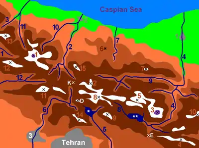
Central Alborz rivers + mountain range map
| Map of central Alborz | Peaks: | 1 Alam-Kuh |
|---|---|---|
 −25 to 500 m (−82 to 1,640 ft) 500 to 1,500 m (1,600 to 4,900 ft) 1,500 to 2,500 m (4,900 to 8,200 ft) 2,500 to 3,500 m (8,200 to 11,500 ft) 3,500 to 4,500 m (11,500 to 14,800 ft) 4,500 to 5,671 m (14,764 to 18,606 ft) |
2 Azad Kuh | 3 Damavand |
| 4 Do Berar | 5 Do Khaharan | |
| 6 Ghal'eh Gardan | 7 Gorg | |
| 8 Kholeno | 9 Mehr Chal | |
| 10 Mishineh Marg | 11 Naz | |
| 12 Shah Alborz | 13 Sialan | |
| 14 Tochal | 15 Varavašt | |
| Rivers: | 0 | |
| 1 Alamut | 2 Chalus | |
| 3 Do Hezar | 4 Haraz | |
| 5 Jajrood | 6 Karaj | |
| 7 Kojoor | 8 Lar | |
| 9 Noor | 10 Sardab | |
| 11 Seh Hazar | 12 Shahrood | |
| Cities: | 1 Amol | |
| 2 Chalus | 3 Karaj | |
| Other: | D Dizin | |
| E Emamzadeh Hashem | K Kandovan Tunnel | |
| * Latyan Dam | ** Lar Dam |
References
- Wells, H. L. (1898) "Across the Elburz Mountains to the Caspian Sea" Scottish Geographical Magazine 14: pp.1-9, page 2
This article is issued from Wikipedia. The text is licensed under Creative Commons - Attribution - Sharealike. Additional terms may apply for the media files.