Ophir, Utah
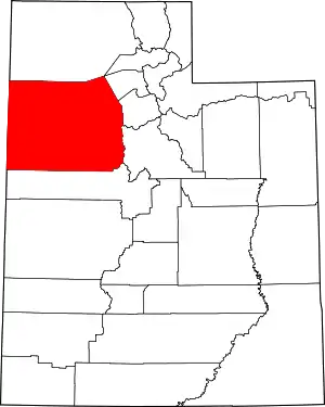
Ophir is a census-designated place in Tooele County, Utah, United States. It is part of the Salt Lake City, Utah Metropolitan Statistical Area. The population was 23 at the 2000 census, a decrease of two from the 1990 figure of 25.
Ophir, Utah | |
|---|---|
 Ophir in winter, December 2007 | |
 Location in Tooele County and the State of Utah | |
 Location of Utah in the United States | |
| Coordinates: 40°22′9″N 112°15′31″W | |
| Country | United States |
| State | Utah |
| County | Tooele |
| Named for | Ophir |
| Area | |
| • Total | 0.2 sq mi (0.4 km2) |
| • Land | 0.2 sq mi (0.4 km2) |
| • Water | 0.0 sq mi (0.0 km2) |
| Elevation | 6,496 ft (1,980 m) |
| Population (2012) | |
| • Total | 40 |
| • Density | 143.0/sq mi (55.2/km2) |
| Time zone | UTC-7 (Mountain (MST)) |
| • Summer (DST) | UTC-6 (MDT) |
| ZIP code | 84071 |
| Area code(s) | 435 |
| FIPS code | 49-56750[1] |
| GNIS feature ID | 1431015[2] |
History
Ophir was named for the nearby canyon and mining district, where gold was discovered in the 1860s. The mining district was named for the biblical Ophir, from where King Solomon brought back gold to Israel.[3]
Prior to 2016, Ophir was one of the smallest incorporated municipalities in Utah. However, after a town government could not be formed from the remaining citizens in 2016, the town was disincorporated.[4]
Geography
According to the United States Census Bureau, the town has a total area of 0.2 square mile (0.4 km2), all land.
Demographics
| Historical population | |||
|---|---|---|---|
| Census | Pop. | %± | |
| 1890 | 249 | — | |
| 1900 | 295 | 18.5% | |
| 1910 | 283 | −4.1% | |
| 1920 | 522 | 84.5% | |
| 1930 | 170 | −67.4% | |
| 1940 | 300 | 76.5% | |
| 1950 | 199 | −33.7% | |
| 1960 | 36 | −81.9% | |
| 1970 | 76 | 111.1% | |
| 1980 | 42 | −44.7% | |
| 1990 | 25 | −40.5% | |
| 2000 | 23 | −8.0% | |
| 2010 | 38 | 65.2% | |
| 2016 (est.) | 55 | [5] | 44.7% |
| U.S. Decennial Census[6][7] | |||
At the 2000 census there were 23 people, 10 households, and 6 families in the town. The population density was 143.0 people per square mile (55.5/km2). There were 33 housing units at an average density of 205.1 per square mile (79.6/km2). The racial makeup of the town was 95.65% White and 4.35% Asian.[1] Of the 10 households 20.0% had children under the age of 18 living with them, 60.0% were married couples living together, and 40.0% were non-families. 40.0% of households were one person and 20.0% were one person aged 65 or older. The average household size was 2.30 and the average family size was 3.17.
The age distribution was 8.7% under the age of 18, 8.7% from 18 to 24, 8.7% from 25 to 44, 43.5% from 45 to 64, and 30.4% 65 or older. The median age was 54 years. For every 100 females, there were 109.1 males. For every 100 females age 18 and over, there were 110.0 males.
The median household income was $50,000 and the median family income was $49,167. Males had a median income of $46,875 versus $13,750 for females. The per capita income for the town was $29,906. None of the population or families were below the poverty line.
See also
- List of cities and towns in Utah
References
- "U.S. Census website". United States Census Bureau. Retrieved 2008-01-31.
- "US Board on Geographic Names". United States Geological Survey. 2007-10-25. Retrieved 2008-01-31.
- Van Atta, Dale (Jan 22, 1977). "You name it - there's a town for it". The Deseret News. pp. W6. Retrieved 18 October 2015.
- Howe, Steve (22 September 2016). "Ophir residents vote to drop incorporation". Tooele Transcript-Bulletin. Retrieved 26 May 2020.
- "Population and Housing Unit Estimates". Retrieved June 9, 2017.
- "Census of Population and Housing". Census.gov. Retrieved June 4, 2015.
- United States Census
External links
![]() Media related to Ophir, Utah at Wikimedia Commons
Media related to Ophir, Utah at Wikimedia Commons
