Oriskany, New York
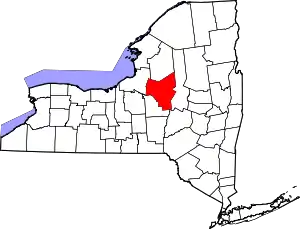
Oriskany is a village in Oneida County, New York, United States. The population was 1,400 at the 2010 census. The name is derived from the Iroquois word for "nettles".
Oriskany, New York | |
|---|---|
 Location in Oneida County and the state of New York. | |
| Coordinates: 43°9.4′N 75°19.9′W | |
| Country | United States |
| State | New York |
| County | Oneida |
| Government | |
| • Mayor | Clifford M. O'Connor, Jr. |
| Area | |
| • Total | 0.79 sq mi (2.05 km2) |
| • Land | 0.79 sq mi (2.05 km2) |
| • Water | 0.00 sq mi (0.00 km2) |
| Elevation | 430 ft (131 m) |
| Population (2010) | |
| • Total | 1,400 |
| • Estimate (2019)[2] | 1,329 |
| • Density | 1,678.03/sq mi (648.21/km2) |
| Time zone | UTC-5 (Eastern (EST)) |
| • Summer (DST) | UTC-4 (EDT) |
| ZIP code | 13424 |
| Area code(s) | 315 |
| FIPS code | 36-55365 |
| GNIS feature ID | 0959480 |
| Website | villageoforiskany |
The Village of Oriskany is in the Town of Whitestown, southeast of the City of Rome. NY-69 passes through the village, which is south of the Erie Canal.
History
The 1777 Battle of Oriskany, during the American Revolution, was fought west of the modern village. At the time of the battle, the Oneida village of "Oriska" was located near the battlefield. The location is marked by the Oriskany Battlefield State Historic Site.
The village was founded in 1811. The Erie Canal passed through the village until it was re-routed during major re-routing and reconstruction later in the 19th century.
While historical records are scarce, the naming of the village has become something of an urban legend. As the legend goes, there was a mix up at the post office - a missing comma. Instead of "Oriska, NY" the envelope was labeled as "Oriska NY" and shortly after "Oriskany, NY" was born.
USS Oriskany
Oriskany had an aircraft carrier named after an American Revolutionary War battle fought there. USS Oriskany served the United States Navy from 1950 to 1976. On May 17, 2006, the ship was laid to rest as an artificial reef in the Gulf of Mexico near Pensacola, Florida. Trinkaus Park, located in Oriskany, has several monuments erected in memory of USS Oriskany. Among the monuments in the park are items from the ship itself including a bell, an anchor, and a Douglas A-4 Skyhawk aircraft.
Geography
Oriskany is located at 43°9.4′N 75°19.9′W (43.1575,-75.3319).[3]
According to the United States Census Bureau, the village has a total area of 0.8 square miles (2.1 km2), all land.
The village is near the confluence of the Mohawk River and Oriskany Creek.
Demographics
| Historical population | |||
|---|---|---|---|
| Census | Pop. | %± | |
| 1990 | 1,450 | — | |
| 2000 | 1,459 | 0.6% | |
| 2010 | 1,400 | −4.0% | |
| 2019 (est.) | 1,329 | [2] | −5.1% |
| U.S. Decennial Census[4] | |||
As of the census[5] of 2000, there were 1,459 people, 500 households, and 379 families residing in the village. The population density was 1,758.0 people per square mile (678.7/km2). There were 576 housing units at an average density of 694.0 per square mile (267.9/km2). The racial makeup of the village was 98.83% White, 0.41% African American, 0.62% Asian, 0.07% from other races, and 0.07% from two or more races. Hispanic or Latino of any race were 0.41% of the population.
There were 553 households, out of which 33.8% had children under the age of 18 living with them, 53.7% were married couples living together, 11.9% had a female householder with no husband present, and 31.3% were non-families. 27.8% of all households were made up of individuals, and 14.1% had someone living alone who was 65 years of age or older. The average household size was 2.50 and the average family size was 3.08.
In the village, the population was spread out, with 24.5% under the age of 18, 6.8% from 18 to 24, 24.7% from 25 to 44, 24.7% from 45 to 64, and 19.3% who were 65 years of age or older. The median age was 41 years. For every 100 females, there were 81.7 males. For every 100 females age 18 and over, there were 78.4 males.
The median income for a household in the village was $38,365, and the median income for a family was $45,066. Males had a median income of $32,917 versus $22,976 for females. The per capita income for the village was $17,087. About 6.6% of families and 10.0% of the population were below the poverty line, including 17.4% of those under age 18 and 13.7% of those age 65 or over.
References
- "2019 U.S. Gazetteer Files". United States Census Bureau. Retrieved July 27, 2020.
- "Population and Housing Unit Estimates". United States Census Bureau. May 24, 2020. Retrieved May 27, 2020.
- "US Gazetteer files: 2010, 2000, and 1990". United States Census Bureau. 2011-02-12. Retrieved 2011-04-23.
- "Census of Population and Housing". Census.gov. Retrieved June 4, 2015.
- "U.S. Census website". United States Census Bureau. Retrieved 2008-01-31.
External links
| Wikisource has the text of the 1911 Encyclopædia Britannica article Oriskany. |
