Peillac
Peillac (Breton: Paolieg, Gallo: Peilla) is a commune in the east of Morbihan department of Brittany in north-western France.
Peillac
Paolieg | |
|---|---|
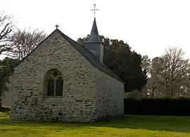
 The chapel of Saint-Julien | |
.svg.png.webp) Coat of arms | |
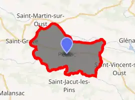
Location of Peillac 
| |
 Peillac  Peillac | |
| Coordinates: 47°42′51″N 2°13′05″W | |
| Country | France |
| Region | Brittany |
| Department | Morbihan |
| Arrondissement | Vannes |
| Canton | Guer |
| Intercommunality | Redon Agglomération |
| Government | |
| • Mayor (2020–2026) | Philippe Jegou[1] |
| Area 1 | 24.57 km2 (9.49 sq mi) |
| Population (2017-01-01)[2] | 1,858 |
| • Density | 76/km2 (200/sq mi) |
| Time zone | UTC+01:00 (CET) |
| • Summer (DST) | UTC+02:00 (CEST) |
| INSEE/Postal code | 56154 /56220 |
| Elevation | 0–82 m (0–269 ft) |
| 1 French Land Register data, which excludes lakes, ponds, glaciers > 1 km2 (0.386 sq mi or 247 acres) and river estuaries. | |
Geography
The canal de Nantes à Brest forms all of the commune's northern border; the river Arz forms all of its southern border.
Demographics
Inhabitants of Peillac are called in French Peillacois.
| Year | Pop. | ±% |
|---|---|---|
| 1793 | 1,764 | — |
| 1800 | 1,737 | −1.5% |
| 1806 | 1,698 | −2.2% |
| 1821 | 1,790 | +5.4% |
| 1831 | 1,935 | +8.1% |
| 1836 | 1,853 | −4.2% |
| 1841 | 1,916 | +3.4% |
| 1846 | 2,006 | +4.7% |
| 1851 | 1,963 | −2.1% |
| 1856 | 1,898 | −3.3% |
| 1861 | 1,903 | +0.3% |
| 1866 | 1,952 | +2.6% |
| 1872 | 1,856 | −4.9% |
| 1876 | 1,965 | +5.9% |
| 1881 | 1,980 | +0.8% |
| 1886 | 1,998 | +0.9% |
| 1891 | 1,996 | −0.1% |
| 1896 | 2,007 | +0.6% |
| 1901 | 2,044 | +1.8% |
| 1906 | 2,002 | −2.1% |
| 1911 | 2,047 | +2.2% |
| 1921 | 1,859 | −9.2% |
| 1926 | 1,849 | −0.5% |
| 1931 | 1,763 | −4.7% |
| 1936 | 1,756 | −0.4% |
| 1946 | 1,754 | −0.1% |
| 1954 | 1,662 | −5.2% |
| 1962 | 1,599 | −3.8% |
| 1968 | 1,536 | −3.9% |
| 1975 | 1,620 | +5.5% |
| 1982 | 1,736 | +7.2% |
| 1990 | 1,694 | −2.4% |
| 1999 | 1,649 | −2.7% |
| 2006 | 1,791 | +8.6% |
| 2007 | 1,812 | +1.2% |
| 2008 | 1,815 | +0.2% |
| 2009 | 1,828 | +0.7% |
| 2010 | 1,839 | +0.6% |
| 2011 | 1,849 | +0.5% |
| 2012 | 1,859 | +0.5% |
| 2013 | 1,859 | +0.0% |
| 2014 | 1,863 | +0.2% |
See also
References
- "Maires du Morbihan" (PDF). Préfecture du Morbihan. 7 July 2020.
- "Populations légales 2017". INSEE. Retrieved 6 January 2020.
- Mayors of Morbihan Association (in French)
- INSEE commune file
| Wikimedia Commons has media related to Peillac. |
This article is issued from Wikipedia. The text is licensed under Creative Commons - Attribution - Sharealike. Additional terms may apply for the media files.