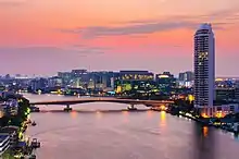
Phra Pin-klao Bridge
The Somdet Phra Pinklao Bridge (Thai: สะพานสมเด็จพระปิ่นเกล้า) is a bridge near the Grand Palace over the Chao Phraya River in Bangkok, Thailand. It links Rattanakosin Island with Thonburi.
Phra Pinklao Bridge สะพานสมเด็จพระปิ่นเกล้า | |
|---|---|
 | |
| Coordinates | 13°45′43″N 100°29′28″E |
| Carries | 6 lanes of roadway, pedestrians |
| Crosses | Chao Phraya River |
| Locale | Bangkok, Thailand |
| Official name | Phra Pinklao Bridge |
| Characteristics | |
| Total length | 658 m |
| Longest span | 110 m |
| Clearance below | 11.5 m |
| History | |
| Opened | 24 September 1973 |
| Location | |

| |
Background
The bridge is named after Pinklao, vice-king of Siam, 1851–1866. In the project phase, the bridge was referred to as the Tha Chang Wang Na Bridge (Thai: สะพานท่าช้างวังหน้า). In June 1973, it was renamed the Somdej Phra Pinklao Bridge in honour of Prince Pinklao.[1]
The Chalerm Sawan 58 Bridge (Thai: สะพานเฉลิมสวรรค์ ๕๘), along Saphan Siaw or "Crescent Bridge" (Thai: สะพานเสี้ยว), had to be dismantled to make way for the new bridge.[2][3][4]
Construction of the bridge started 4 August 1971. It was opened to traffic on 24 September 1973 by Prime Minister Thanom Kittikachorn. The bridge was built by the joint company Obayashi Gumi Ltd. and Sumitomo Construction Co. Ltd under the supervision of Swiss Engineering Project (SEP) which acted as trustee for the Department of Public and Municipal Works (DPMW).[5]
The main drivers behind the construction of the bridge were:[6]
- To alleviate the traffic congestion over and around the Memorial Bridge and to shorten travel time and cut costs
- To foster inter-city relations between Bangkok and Thonburi
- To facilitate the development in the vicinity of the bridge
The Sa-nga Phanit Co., Ltd. (Thai: บริษัท สง่าพานิช จำกัด) was the main contractor for the Phan Phiphop Lila Bridge (Thai: สะพานผ่านพิภพลีลา) extension over Khlong Khu Mueang Doem (Thai: คลองคูเมืองเดิม)[a] to match the new bridge system at a cost of 6,880,000 baht.[5]
It is feared that the heavy traffic crossing Pinklao Bridge could cause structural damage to the old buildings on Ratchadamnoen Avenue.[7] Some residents expressed their desire in 2010 to have the bridge dismantled mainly due to the air and noise pollution it brings to the old quarter of Bangkok.[7] The Cheonggyecheon project in Seoul is given as an example of the positive effects the dismantlement could have.[7]
Notes
References
- Special supplement of the Bangkok Post/World newspaper - September 24, 1973
- "ศูนย์ข้อมูลเกาะรัตนโกสินทร์". www.thapra.lib.su.ac.th. Retrieved 2016-12-18.
- "สะพานเสี้ยว | ศูนย์ข้อมูลเกาะรัตนโกสินทร์". www.lib.su.ac.th. Archived from the original on 2016-12-24. Retrieved 2016-12-23.
- Dick van Der Speck; Wisarut Bholsithi; Wally Higgins (2015). Bangkok Tramways; Eighty Years 1888-1968. Bangkok: White Lotus. p. 24. ISBN 978-974-8495-37-8.
- Special supplement of The Nation newspaper - September 24, 1973, p. 12.
- "Kingdom of Thailand; Feasibility report on Bangkok-Thonburi Bridge No. 1 Project" (PDF). Overseas Technical Cooperation Agency. Retrieved 20 December 2016.
- Wanchareon, Supoj (19 August 2010). "Residents seek dismantling of bridge". Bangkok Post. Retrieved 20 December 2016.
External links
- Phra Pin Klao Bridge at Structurae
- Bureau of Maintenance and Traffic Safety, Thailand
- YOUTUBE VIDEO Construction of Phra Pinklao Bridge circa 1972