Pierre-Bénite
Pierre-Bénite is a commune in the Metropolis of Lyon in Auvergne-Rhône-Alpes region in eastern France.
Pierre-Bénite | |
|---|---|
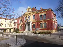 The town hall in Pierre-Bénite | |
.svg.png.webp) Coat of arms | |
Location of Pierre-Bénite 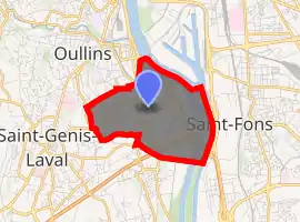
| |
 Pierre-Bénite  Pierre-Bénite | |
| Coordinates: 45°42′16″N 4°49′30″E | |
| Country | France |
| Region | Auvergne-Rhône-Alpes |
| Metropolis | Metropolis of Lyon |
| Arrondissement | Lyon |
| Government | |
| • Mayor (2014–2020) | Jérôme Moroge (LR) |
| Area 1 | 4.48 km2 (1.73 sq mi) |
| Population (2017-01-01)[1] | 10,390 |
| • Density | 2,300/km2 (6,000/sq mi) |
| Demonym(s) | Pierre-Bénitain(e)s |
| Time zone | UTC+01:00 (CET) |
| • Summer (DST) | UTC+02:00 (CEST) |
| INSEE/Postal code | 69152 /69310 |
| Elevation | 155–232 m (509–761 ft) (avg. 167 m or 548 ft) |
| Website | www.pierrebenite.fr |
| 1 French Land Register data, which excludes lakes, ponds, glaciers > 1 km2 (0.386 sq mi or 247 acres) and river estuaries. | |
Geography
Pierre-Bénite, a suburb around 6 kilometers (3.73 miles) south of Lyon, extends over 440 hectares (1087.26 acres) on the right bank of the Rhône River, alongside the A7 motorway. It is limited to the north by Lyon, to the west by Oullins, to the southwest by Saint-Genis-Laval, to the south by Irigny, and to the east by the Rhône River, across from Saint-Fons.
See also
References
- "Populations légales 2017". INSEE. Retrieved 6 January 2020.
| Wikimedia Commons has media related to Pierre-Bénite. |
This article is issued from Wikipedia. The text is licensed under Creative Commons - Attribution - Sharealike. Additional terms may apply for the media files.