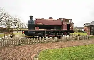
Pilling railway station
Pilling railway station served the villages of Pilling and Stake Pool in Lancashire, England.
Pilling | |
|---|---|
 | |
| Location | Borough of Wyre England |
| Coordinates | 53.9224°N 2.8946°W |
| Grid reference | SD413477 |
| Platforms | 2 |
| Other information | |
| Status | Disused |
| History | |
| Original company | Garstang and Knot-End Railway |
| Pre-grouping | Knott End Railway |
| Post-grouping | London, Midland and Scottish Railway |
| Key dates | |
| 5 December 1870 | Opened |
| 11 March 1872 | Closed |
| 17 May 1875 | Reopened |
| 31 March 1930 | Closed |
| Garstang & Knot-End Rly | ||||||||||||||||||||||||||||||||||||||||||||||||||||||||||||||||||
|---|---|---|---|---|---|---|---|---|---|---|---|---|---|---|---|---|---|---|---|---|---|---|---|---|---|---|---|---|---|---|---|---|---|---|---|---|---|---|---|---|---|---|---|---|---|---|---|---|---|---|---|---|---|---|---|---|---|---|---|---|---|---|---|---|---|---|
| ||||||||||||||||||||||||||||||||||||||||||||||||||||||||||||||||||
Under the Garstang and Knot-End Railway
The station opened on 5 December 1870 as the terminus of the Garstang and Knot-End Railway when it opened the 7 miles 1 chain (11.3 km) long line from Garstang.[lower-alpha 1][1][2][3]
The station was located on the southern edge of Stake Pool village to the east of the road running south (now Bradshaw Lane), and was sometimes called Stake Pool station by the local press.[lower-alpha 2] Although called Pilling station it was about 1,500 yards (1,400 m) from Pilling village across country, or about 1.5 miles (2.4 km) by road.[4]
The line was a single track and a passing loop, which appeared to cross the adjacent road on the level, was provided at the station to enable the locomotive to run round the train. At this time there was one platform to the south of the running line and a small building between the platform and the road.[4] A small goods yard was to the south and east of the station able to accommodate most types of goods including live stock, it was equipped with a half ton crane.[5] The initial service was for four trains in each direction.[6]
Under the Knott End Railway
The railway company was bought out by the Knott End Railway and the line was extended to Knott End on 30 July 1908 at which time a second platform was built so that the platforms were either side of the passing loop, the goods yard was extended and a goods shed provided. A substantially larger station building was constructed immediately south of the southern platform.[3][7]
In 1922 the service had increased to six trains each way, with an extra train on Fridays to and from Knott End. There were no services on Sundays.[8]
LMS and closure
The station closed to passengers on 31 March 1930.[2] Despite being closed the station was still available for goods and parcels, by 1938 the crane had been upgraded to 1 ton capacity.[9] The line and station closed for freight on 31 July 1963.[10] In 1981 it was reported that the station goods yard was now a small industrial estate and the former station house had become a private dwelling.[lower-alpha 3][11]
| Preceding station | Disused railways | Following station | ||
|---|---|---|---|---|
| Cockerham Cross Halt | Garstang and Knot-End Railway 1870 – 1908 |
Terminus | ||
| Cockerham Cross Halt | Knott End Railway Garstang and Knot-End Railway 1908 – 1921 Amalgamated |
Preesall | ||
| Cockerham Cross Halt | Knott End Railway Garstang and Knot-End Railway 1921 – 1923 |
Carr Lane Halt New station | ||
| Garstang Road Halt New station |
London, Midland and Scottish Railway Knott End Railway 1923 – 1930 Grouping |
Carr Lane Halt |
References
Notes
- Railways in the United Kingdom are, for historical reasons, measured in miles and chains. A chain is 22 yards (20 m) long, there are 80 chains to the mile.
- See for example "District News:Garstang". Preston Chronicle. 2 October 1875. p. 3. Retrieved 20 September 2020 – via British Newspaper Archive.
- Online mapping with street view shows the same situation in 2020
Citations
- "Engineer's Line Reference KEL Knott End Line". Railway Codes. 26 March 2020. Retrieved 20 September 2020.
- Quick 2019, p. 322.
- Grant 2017, p. 214.
- "Pilling Station on OS 25 inch map Lancashire XXXVIII.16 (Pilling)". National Library of Scotland. 1893. Retrieved 20 September 2020.
- The Railway Clearing House 1970, p. 433.
- "Garstang and Knot End Railway". Lancaster Gazette. 31 December 1870. p. 5. Retrieved 20 September 2020 – via British Newspaper Archive.
- "Pilling Station on OS 25 inch map Lancashire XXXVIII.16 (Pilling)". National Library of Scotland. 1912. Retrieved 20 September 2020.
- Bradshaw 1985, p. 590.
- The Railway Clearing House 1938, p. 467.
- Hurst 1992, p. 22 (ref 1098).
- Marshall 1981, p. 154.
Bibliography
- Bradshaw, George (1985) [July 1922]. Bradshaw's General Railway and Steam Navigation guide for Great Britain and Ireland: A reprint of the July 1922 issue. Newton Abbot: David and Charles. ISBN 978-0-7153-8708-5. OCLC 12500436.
- Grant, Donald J. (2017). Directory of the Railway Companies of Great Britain (1st ed.). Kibworth Beauchamp, Leicestershire: Troubador Publishing Ltd. ISBN 978-1-78803-768-6.
- Hurst, Geoffrey (1992). Register of Closed Railways: 1948-1991. Worksop, Nottinghamshire: Milepost Publications. ISBN 0-9477-9618-5.
- Marshall, John (1981). Forgotten Railways:North-West England. David & Charles. ISBN 0-7153-8003-6.
- Quick, Michael (2019) [2001]. Railway passenger stations in Great Britain: a chronology (PDF) (5th ed.). Railway and Canal Historical Society.
- The Railway Clearing House (1970) [1904]. The Railway Clearing House Handbook of Railway Stations 1904 (1970 D&C Reprint ed.). Newton Abbot: David & Charles Reprints. ISBN 0-7153-5120-6.
- The Railway Clearing House (1938). Official Hand-book of Railway Stations 1938. London: The Railway Clearing House.
Further reading
- Rush, R.W.; Price, M.R.C. (1964). The Garstang & Knott End Railway. Oakwood Press.
External links
- "Pilling station". Disused Stations. Retrieved 20 September 2020.
- "The Garstang and Knott End Railway – Part 1". Roger Farnworth. Retrieved 21 September 2020.