Quebec Route 173
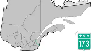
Route 173 (Route-du-Président-Kennedy) is a major north/south highway on the south shore of the St. Lawrence River in Quebec, Canada, named after the assassinated American president, John F. Kennedy. Its southern terminus is at the Armstrong-Jackman Border Crossing in Saint-Théophile in the hamlet of Armstrong, at the border with Maine (U.S. Route 201 / Maine SR 6), and its northern terminus is in Lévis at the junction of Route 132. Route 173 follows the Chaudière River for most of its course, from Saint-Georges, down to Scott, where the route takes a more northeastern route towards Lévis, crossing the Etchemin River in the municipality of Saint-Henri-de-Lévis.
| ||||
|---|---|---|---|---|
 | ||||
| Route information | ||||
| Maintained by Transports Québec | ||||
| Length | 142.6 km[1] (88.6 mi) | |||
| Major junctions | ||||
| South end | ||||
| North end | ||||
| Location | ||||
| Major cities | Lévis, Saint-Georges, Sainte-Marie, Vallée-Jonction, Beauceville | |||
| Highway system | ||||
| ||||

Municipalities along Route 173
.jpg.webp)
Quebec Route 173 in Pintendre
- Saint-Côme-Linière
- Saint-Georges
- Notre-Dame-des-Pins
- Beauceville
- Saint-Joseph-de-Beauce
- Vallée-Jonction
- Sainte-Marie
- Scott
- Saint-Isidore
- Saint-Henri-de-Levis
- Pintendre
- Lévis
See also
References
- Ministère des transports, "Distances routières", page 75, Les Publications du Québec, 2005
External links
- Provincial Route Map (Courtesy of the Quebec Ministry of Transportation) (in French)
- Route 173 on Google Maps
This article is issued from Wikipedia. The text is licensed under Creative Commons - Attribution - Sharealike. Additional terms may apply for the media files.