Saint-Avit, Loir-et-Cher
Saint-Avit is a former commune in the Loir-et-Cher department of central France. On 1 January 2018, it was merged into the new commune of Couëtron-au-Perche.[2]
Saint-Avit | |
|---|---|
Part of Couëtron-au-Perche | |
.svg.png.webp) Coat of arms | |
Location of Saint-Avit 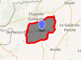
| |
 Saint-Avit  Saint-Avit | |
| Coordinates: 48°05′33″N 0°55′01″E | |
| Country | France |
| Region | Centre-Val de Loire |
| Department | Loir-et-Cher |
| Arrondissement | Vendôme |
| Canton | Le Perche |
| Commune | Couëtron-au-Perche |
| Area 1 | 14.83 km2 (5.73 sq mi) |
| Population (2017)[1] | 98 |
| • Density | 6.6/km2 (17/sq mi) |
| Time zone | UTC+01:00 (CET) |
| • Summer (DST) | UTC+02:00 (CEST) |
| Postal code | 41170 |
| Elevation | 156–240 m (512–787 ft) (avg. 207 m or 679 ft) |
| 1 French Land Register data, which excludes lakes, ponds, glaciers > 1 km2 (0.386 sq mi or 247 acres) and river estuaries. | |
Population
| Year | Pop. | ±% |
|---|---|---|
| 1793 | 427 | — |
| 1806 | 426 | −0.2% |
| 1821 | 424 | −0.5% |
| 1831 | 435 | +2.6% |
| 1841 | 458 | +5.3% |
| 1851 | 444 | −3.1% |
| 1861 | 428 | −3.6% |
| 1872 | 451 | +5.4% |
| 1881 | 396 | −12.2% |
| 1891 | 402 | +1.5% |
| 1901 | 429 | +6.7% |
| 1911 | 436 | +1.6% |
| 1921 | 351 | −19.5% |
| 1931 | 351 | +0.0% |
| 1946 | 295 | −16.0% |
| 1954 | 278 | −5.8% |
| 1962 | 262 | −5.8% |
| 1968 | 240 | −8.4% |
| 1975 | 189 | −21.3% |
| 1982 | 146 | −22.8% |
| 1990 | 114 | −21.9% |
| 1999 | 121 | +6.1% |
| 2005 | 109 | −9.9% |
| 2015 | 98 | −10.1% |
References
- Téléchargement du fichier d'ensemble des populations légales en 2017, INSEE
- Arrêté préfectoral 10 July 2017 (in French)
| Wikimedia Commons has media related to Saint-Avit (Loir-et-Cher). |
| Authority control |
|---|
This article is issued from Wikipedia. The text is licensed under Creative Commons - Attribution - Sharealike. Additional terms may apply for the media files.