Saint-Ciers-du-Taillon
Saint-Ciers-du-Taillon is a commune in the Charente-Maritime department in the Nouvelle-Aquitaine region in southwestern France.
Saint-Ciers-du-Taillon | |
|---|---|
 A view within Saint-Ciers-du-Taillon | |
Location of Saint-Ciers-du-Taillon 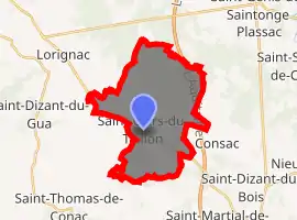
| |
 Saint-Ciers-du-Taillon  Saint-Ciers-du-Taillon | |
| Coordinates: 45°25′26″N 0°38′20″W | |
| Country | France |
| Region | Nouvelle-Aquitaine |
| Department | Charente-Maritime |
| Arrondissement | Jonzac |
| Canton | Pons |
| Government | |
| • Mayor (2008–2014) | Patrick Chérat |
| Area 1 | 22.1 km2 (8.5 sq mi) |
| Population (2017-01-01)[1] | 550 |
| • Density | 25/km2 (64/sq mi) |
| Time zone | UTC+01:00 (CET) |
| • Summer (DST) | UTC+02:00 (CEST) |
| INSEE/Postal code | 17317 /17240 |
| Elevation | 14–101 m (46–331 ft) |
| 1 French Land Register data, which excludes lakes, ponds, glaciers > 1 km2 (0.386 sq mi or 247 acres) and river estuaries. | |

Church Saint-Cyriaque 12-13th century - Saint-Ciers-du-Taillon (2013)
Population
| Year | Pop. | ±% |
|---|---|---|
| 1962 | 685 | — |
| 1968 | 727 | +6.1% |
| 1975 | 634 | −12.8% |
| 1982 | 576 | −9.1% |
| 1990 | 569 | −1.2% |
| 1999 | 524 | −7.9% |
| 2008 | 507 | −3.2% |
References
- "Populations légales 2017". INSEE. Retrieved 6 January 2020.
External links
| Wikimedia Commons has media related to Saint-Ciers-du-Taillon. |
| Authority control |
|---|
This article is issued from Wikipedia. The text is licensed under Creative Commons - Attribution - Sharealike. Additional terms may apply for the media files.