Saint-Denis, Gard
Saint-Denis (Occitan: Sent Daunís) is a commune in the Gard department in southern France. It is around 15 km north-east of Alès.
Saint-Denis | |
|---|---|
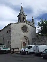 The church of Saint-Denis | |
.svg.png.webp) Coat of arms | |
Location of Saint-Denis 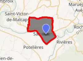
| |
 Saint-Denis  Saint-Denis | |
| Coordinates: 44°14′02″N 4°15′09″E | |
| Country | France |
| Region | Occitanie |
| Department | Gard |
| Arrondissement | Alès |
| Canton | Rousson |
| Government | |
| • Mayor (2020–2026) | Sylvette Molieres[1] |
| Area 1 | 3.65 km2 (1.41 sq mi) |
| Population (2017-01-01)[2] | 294 |
| • Density | 81/km2 (210/sq mi) |
| Time zone | UTC+01:00 (CET) |
| • Summer (DST) | UTC+02:00 (CEST) |
| INSEE/Postal code | 30247 /30500 |
| Elevation | 111–156 m (364–512 ft) (avg. 200 m or 660 ft) |
| 1 French Land Register data, which excludes lakes, ponds, glaciers > 1 km2 (0.386 sq mi or 247 acres) and river estuaries. | |
Population
|
|
See also
References
- "Répertoire national des élus: les maires". data.gouv.fr, Plateforme ouverte des données publiques françaises (in French). 2 December 2020. Retrieved 7 December 2020.
- "Populations légales 2017". INSEE. Retrieved 6 January 2020.
| Wikimedia Commons has media related to Saint-Denis (Gard). |
| Authority control |
|---|
This article is issued from Wikipedia. The text is licensed under Creative Commons - Attribution - Sharealike. Additional terms may apply for the media files.