Saint-Pierre-des-Champs
Saint-Pierre-des-Champs is a commune in the Aude department in southern France.
Saint-Pierre-des-Champs | |
|---|---|
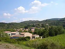 A general view of Saint-Pierre-des-Champs | |
.svg.png.webp) Coat of arms | |
Location of Saint-Pierre-des-Champs 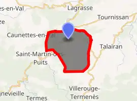
| |
 Saint-Pierre-des-Champs  Saint-Pierre-des-Champs | |
| Coordinates: 43°03′34″N 2°36′20″E | |
| Country | France |
| Region | Occitanie |
| Department | Aude |
| Arrondissement | Narbonne |
| Canton | Les Corbières |
| Intercommunality | Région Lézignanaise, Corbières et Minervois |
| Government | |
| • Mayor (2008–2014) | Jean-Pierre Maisonnade |
| Area 1 | 15.89 km2 (6.14 sq mi) |
| Population (2017-01-01)[1] | 181 |
| • Density | 11/km2 (30/sq mi) |
| Demonym(s) | Saint-Pierrois |
| Time zone | UTC+01:00 (CET) |
| • Summer (DST) | UTC+02:00 (CEST) |
| INSEE/Postal code | 11363 /11220 |
| Elevation | 133–520 m (436–1,706 ft) (avg. 146 m or 479 ft) |
| 1 French Land Register data, which excludes lakes, ponds, glaciers > 1 km2 (0.386 sq mi or 247 acres) and river estuaries. | |
Population
| Year | Pop. | ±% |
|---|---|---|
| 1962 | 121 | — |
| 1968 | 155 | +28.1% |
| 1975 | 152 | −1.9% |
| 1982 | 121 | −20.4% |
| 1990 | 134 | +10.7% |
| 1999 | 127 | −5.2% |
| 2008 | 164 | +29.1% |
Geography
The commune is located in the Corbières Massif.
The village lies on the right bank of the Orbieu, which flows northeast through the western part of the commune.
References
- "Populations légales 2017". INSEE. Retrieved 6 January 2020.
| Wikimedia Commons has media related to Saint-Pierre-des-Champs. |
| Authority control |
|---|
This article is issued from Wikipedia. The text is licensed under Creative Commons - Attribution - Sharealike. Additional terms may apply for the media files.