Saint Meinrad, Indiana
Saint Meinrad is a census-designated place (CDP) in Harrison Township, Spencer County, Indiana, United States. Located along the Anderson River and just off Interstate 64,[3] it is home to the St. Meinrad Archabbey. It is situated about 55 miles east of Evansville. Because of the archabbey, St. Meinrad, along with Harrison Township, lies within the Archdiocese of Indianapolis instead of the much closer Diocese of Evansville, in which lies the rest of Spencer County.

Saint Meinrad, Indiana
Saint Meinrad, Indiana | |
|---|---|
 St Meinrad Archabbey | |
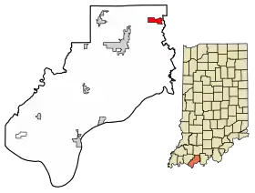
 Location of St. Meinrad in Spencer County, Indiana. | |
| Coordinates: 38°10′16″N 86°48′33″W | |
| Country | United States |
| State | Indiana |
| County | Spencer |
| Township | Harrison |
| Elevation | 443 ft (135 m) |
| Time zone | UTC-6 (Central (CST)) |
| • Summer (DST) | UTC-5 (CDT) |
| ZIP code | 47577 |
| Area code(s) | 812, 930 |
| FIPS code | 18-67176[2] |
| GNIS feature ID | 442728 |
History
Saint Meinrad was laid out in 1861, and named after the local St. Meinrad Archabbey.[4] A post office has been in operation at Saint Meinrad since 1862.[5]
Geography
St. Meinrad is located at geographical coordinates 38° 10′ 19″ North, 86° 48′ 34″ West (38.172039, -86.809464).
References
- "US Board on Geographic Names". United States Geological Survey. 2007-10-25. Retrieved 2008-01-31.
- "U.S. Census website". United States Census Bureau. Retrieved 2008-01-31.
- "Saint Meinrad, Indiana". Geographic Names Information System. United States Geological Survey. Retrieved 2016-07-09.
- History of Warrick, Spencer, and Perry Counties, Indiana: From the Earliest Time to the Present. Goodspeed. 1885. p. 371.
- "Spencer County". Jim Forte Postal History. Retrieved 4 October 2015.
External links
This article is issued from Wikipedia. The text is licensed under Creative Commons - Attribution - Sharealike. Additional terms may apply for the media files.