Sakura, Chiba
Sakura (佐倉市, Sakura-shi) is a city located in Chiba Prefecture, Japan. As of 1 November 2020, the city had an estimated population of 173,740 in 78,483 households and a population density of 1700 persons per km².[1] The total area of the city is 103.59 square kilometres (40.00 sq mi).
Sakura
佐倉市 | |||||||||
|---|---|---|---|---|---|---|---|---|---|

| |||||||||
 Flag  Seal | |||||||||
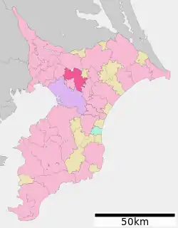
 Location of Sakura in Chiba Prefecture | |||||||||
 Sakura | |||||||||
| Coordinates: 35°43′N 140°13′E | |||||||||
| Country | Japan | ||||||||
| Region | Kantō | ||||||||
| Prefecture | Chiba | ||||||||
| Government | |||||||||
| • Mayor | Sango Nishida | ||||||||
| Area | |||||||||
| • Total | 103.59 km2 (40.00 sq mi) | ||||||||
| Population (December 2020) | |||||||||
| • Total | 173,740 | ||||||||
| • Density | 1,700/km2 (4,300/sq mi) | ||||||||
| Time zone | UTC+9 (Japan Standard Time) | ||||||||
| -Tree | Sakura | ||||||||
| - Flower | Hanashōbu (Iris ensata var. ensata) | ||||||||
| Phone number | 043-484-1111 | ||||||||
| Address | 97, Kairinjimachi, Sakura-shi, Chiba-ken 285-8501 | ||||||||
| Website | Official website | ||||||||

Geography
Sakura is located in northeastern Chiba Prefecture on the Shimōsa Plateau.[2] It is situated approximately 40 kilometers northeast of Tokyo and 15 kilometers from Narita International Airport. Chiba City, the prefectural capital, lies 15 kilometers southwest of Sakura. Lake Inba forms the northern city limits.[3][4]
Neighboring municipalities
Chiba Prefecture
Climate
Sakura has a Humid subtropical climate (Köppen Cfa) characterized by warm summers and cool winters with light to no snowfall. The average annual temperature in Sakura is 14.8 °C. The average annual rainfall is 1428 mm with September as the wettest month. The temperatures are highest on average in August, at around 26.3 °C, and lowest in January, at around 4.5 °C.[5]
Demographics
Per Japanese census data,[6] the population of Sakura increased rapidly from the 1960s to the 1980s, and at a lesser extent since.
| Year | Pop. | ±% |
|---|---|---|
| 1960 | 36,869 | — |
| 1970 | 60,068 | +62.9% |
| 1980 | 101,180 | +68.4% |
| 1990 | 144,688 | +43.0% |
| 2000 | 170,934 | +18.1% |
| 2010 | 12,176 | −92.9% |
History
The area around Sakura has been inhabited since prehistory, and archaeologists have found numerous Kofun period burial tumuli in the area, along with the remains of a Hakuho period Buddhist temple. During the Kamakura and Muromachi periods, the area was controlled by the Chiba clan. During the Sengoku period, the Chiba clan fought the Satomi clan to the south, and the Later Hōjō clan to the west. After the defeat of the Chiba clan, the area came within the control of Tokugawa Ieyasu, who assigned one of his chief generals, Doi Toshikatsu to rebuild Chiba Castle and to rule over Sakura Domain as a daimyō.[3] Doi rebuilt the area as a jōkamachi, or castle town, which became the largest castle town in the Bōsō region.[2][4] Under the Tokugawa shogunate, Sakura Domain came to be ruled for most of the Edo period under the Hotta clan. In the Bakumatsu period the domain became a center for rangaku studies, centered on the Juntendō school of the doctor Taizen Satō (1804 – 1872).[2][7] The Juntendō and other educational institutions in Sakura contributed greatly to the Meiji Restoration.[2] After the abolition of Sakura Domain, the area eventually became part of Chiba Prefecture.
Sakura Town was one of several towns and villages created on April 1, 1889 under Inba District with the establishment of the modern municipalities system. On March 31, 1954, Sakura achieved city status through merger of the neighboring municipalities of Usui, Wada, Nego, Yadomi, and Shizu.[2]
Government
Sakura has a mayor-council form of government with a directly elected mayor and a unicameral city council of 28 members. Sakura contributes three members to the Chiba Prefectural Assembly. In terms of national politics, the city is part of Chiba 9th district of the lower house of the Diet of Japan.
Economy
Sakura is a regional commercial center and, due to its numerous train connections, a bedroom community for nearby Chiba and Tokyo, with more than 24% of the population commuting, per the 2010 census.
Education
- Keiai University branch campus
- Chiba Keiai Junior College
- Wayo Women's University branch campus
- Sakura has 23 public elementary schools and 11 public middle schools operated by the city government, and four public high schools operated by the Chiba Prefectural Board of Education.
Transportation
Railway
![]() JR East – Narita Line, Sōbu Main Line
JR East – Narita Line, Sōbu Main Line
![]() Keisei Electric Railway - Keisei Main Line
Keisei Electric Railway - Keisei Main Line
- Shizu - Yūkarigaoka - Keisei-Usui - Keisei-Sakura - Ōsakura
■ Yamaman - Yamaman Yūkarigaoka Line
- Yūkarigaoka - Chiku Center - Kōen - Joshidai- Chūgakkō - Ino
Local attractions

Sakura boasts a number of tourist attractions, including the large National Museum of Japanese History [8] located on the ruins of Sakura Castle.[3] Several samurai houses near the old castle are open to the public and are protected as Important Cultural Properties. Other sights of interest include the Tsukamoto Sword Museum, Sakura Museum of History and Folklore, Sakura City Museum of Art, and the Sakura Juntendo Memorial Building. Nearby is also the Kawamura Memorial Museum of Art.
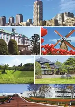
In 1994 on the 40th anniversary of the city's foundation a Dutch windmill called De Liefde was erected by the Dutch millwright company "Verbij Hoogmade BV" on the south-eastern shore of Lake Inba as a landmark of Sakura Furusato Square. The mill serving as a polder mill is named after the first Dutch sailing ship which landed on the Japanese shore in 1600. It is the only windmill of this type in Japan (a so-called "ground-sailer", which means a windmill whose sails reach almost down to the ground.
Noted people from Sakura
- Hayashi Tadasu, Meiji period statesman
- Tsuda Sen, Meiji period statesman
- Nagashima Shigeo, Professional baseball player
- BUMP OF CHICKEN, Japanese alternative rock group
- Yoshimi Osawa, Japanese judoka and one of only three living Kodokan 10th dan
- Ben-K, Japanese professional wrestler (Real Name: Futa Nakamura (中村風太, Nakamura Futa)
- Daisuke Fukushima, Japanese Olympic show jumping rider
- Shinnosuke Nakatani, Japanese footballer, playing as a defender for Nagoya Grampus in J1 League
- Katsuya Nagato, Japanese footballer who plays as a defender for Kashima Antlers in the J1 League
- Sakiko Odaka, Japanese women's professional shogi player ranked 1-kyū
- Shinnosuke Shigenobu, Japanese professional baseball outfielder for the Yomiuri Giants in Japan's Nippon Professional Baseball
- Asai Chū, Japanese painter, noted for his pioneering work in developing the yōga (Western-style) art movement in late 19th century and early twentieth-century Japanese painting
References
- "Sakura city official statistics" (in Japanese). Japan.
- "佐倉(市)" [Sakura (City)]. Nihon Daihyakka Zensho (Nipponika) (in Japanese). Tokyo: Shogakukan. 2012. OCLC 153301537. Retrieved 2012-06-20.
- "Sakura". Encyclopedia of Japan. Tokyo: Shogakukan. 2012. OCLC 56431036. Archived from the original on 2007-08-25. Retrieved 2012-06-30.
- "佐倉" [Sakura]. Dijitaru daijisen (in Japanese). Tokyo: Shogakukan. 2012. OCLC 56431036. Archived from the original on 2007-08-25. Retrieved 2012-06-24.
- Sakura climate data
- Sakura population statistics
- "佐藤泰然" [Satō Taizen]. Nihon Daihyakka Zensho (Nipponika) (in Japanese). Tokyo: Shogakukan. 2012. OCLC 153301537. Archived from the original on 2007-08-25. Retrieved 2012-06-29.
- Official website, National Museum of Japanese History; phone 043-486-0123, address 117 Jonai-cho.