San Nicolas, Pangasinan
San Nicolas, officially the Municipality of San Nicolas (Pangasinan: Baley na San Nicolas; Ilocano: Ili ti San Nicolas; Tagalog: Bayan ng San Nicolas), is a 1st class municipality in the province of Pangasinan, Philippines. According to the 2015 census, it has a population of 35,574 people. [3]
San Nicolas | |
|---|---|
| Municipality of San Nicolas | |
 San Nicolas Town Hall | |
 Seal | |
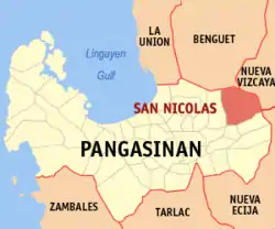 Map of Pangasinan with San Nicolas highlighted | |
OpenStreetMap 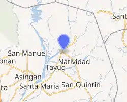
| |
.svg.png.webp) San Nicolas Location within the Philippines | |
| Coordinates: 16°04′12″N 120°45′55″E | |
| Country | |
| Region | Ilocos Region (Region I) |
| Province | Pangasinan |
| District | 6th district |
| Founded | 1610 |
| Barangays | 33 (see Barangays) |
| Government | |
| • Type | Sangguniang Bayan |
| • Mayor | Alicia Primicias |
| • Vice Mayor | Alvin O. Bravo |
| • Representative | Tyrone D. Agabas |
| • Electorate | 26,109 voters (2019) |
| Area | |
| • Total | 210.20 km2 (81.16 sq mi) |
| Elevation | 102 m (335 ft) |
| Population | |
| • Total | 35,574 |
| • Density | 170/km2 (440/sq mi) |
| • Households | 8,133 |
| Economy | |
| • Income class | 1st municipal income class |
| • Poverty incidence | 13.05% (2015)[4] |
| • Revenue | ₱120,482,854.87 (2016) |
| Time zone | UTC+8 (PST) |
| ZIP code | 2447 |
| PSGC | |
| IDD : area code | +63 (0)75 |
| Climate type | tropical monsoon climate |
| Native languages | Pangasinan Ilocano Kallahan language Tagalog |
It is the only town that borders Nueva Vizcaya.
Soon the completion building and concreting of the Villa Verde Road will be a short cut to go to Santa Fe, Nueva Vizcaya and easier access to the upland barangays of Malico and Fianza.
Barangay
San Nicolas is located in north-eastern part of Pangasinan and is politically subdivided into 33 barangays.
- Bensican
- Cabitnongan
- Caboloan
- Cacabugaoan
- Calanutian
- Calaocan
- Camanggaan/
- Camindoroan/
- Casaratan/
- Dalumpinas/
- Fianza/
- Lungao/
- Malico/
- Malilion/
- Nagkaysa/
- Nining
- Poblacion East/ the epicenter
- Poblacion West/ the center
- Salingcob
- Salpad
- San Felipe East
- San Felipe West
- San Isidro (Santa Cruzan)
- San Jose Del Rio
- San Rafael Centro
- San Rafael East
- San Rafael West
- San Roque
- Santa Maria East
- Santa Maria West
- Santo Tomas
- Siblot
- Sobol
Places of interest

San Nicolas is a place with many waterfalls from the Caraballo Mountain Range and a number of rivers that serve as a picnic ground for vacationers during holidays and summertime.[5]
Lipit falls are located in Barangay Santa Maria East. It is an hour trail from the Red Arrow Monument along Cabalitian River. Best time to visit the place is during the summertime but it is also safe to go there during rainy seasons.
Agpay falls is in Barangay San Felipe East. During the 1970s up to the 1980s it was actually one of the best natural tourist spots in eastern Pangasinan.
Other waterfalls of interest include: Pinsal falls 1, 2 and 3, located in Sitio Nagsimbaoaan in Barangay Cacabugaoan; Mambolo falls, located at Barangay Salpad and Pinsal Bensican in brgy. Bensican; and Baracbac falls are located in Barangay Fianza just north of Sitio Puyao.
Mejias Resort is located at town proper of San Nicolas. It has a wide space for picnic area and reception hall for kinds of parties and events. They are accepting decorating services and catering for a variety of special events, including the concept and design, planning, day of coordination, and much more. They have also swimming pools for adults and children.
Krystala de Corazon is located at Barangay Calaocan, San Nicolas.
Esperanza's Garden is located at Barangay Cabitnongan, San Nicolas.
Cabalisian River - crystal clear water located at Barangay Santa Maria.
Demographics
|
| ||||||||||||||||||||||||||||||||||||||||||||||||
| Source: Philippine Statistics Authority [3] [6] [7][8] | |||||||||||||||||||||||||||||||||||||||||||||||||
Climate
| Climate data for San Nicolas, Pangasinan | |||||||||||||
|---|---|---|---|---|---|---|---|---|---|---|---|---|---|
| Month | Jan | Feb | Mar | Apr | May | Jun | Jul | Aug | Sep | Oct | Nov | Dec | Year |
| Average high °C (°F) | 31 (88) |
31 (88) |
32 (90) |
34 (93) |
35 (95) |
34 (93) |
32 (90) |
32 (90) |
32 (90) |
32 (90) |
32 (90) |
31 (88) |
32 (90) |
| Average low °C (°F) | 22 (72) |
22 (72) |
22 (72) |
24 (75) |
24 (75) |
24 (75) |
23 (73) |
23 (73) |
24 (75) |
23 (73) |
23 (73) |
22 (72) |
23 (73) |
| Average precipitation mm (inches) | 13.6 (0.54) |
10.4 (0.41) |
18.2 (0.72) |
15.7 (0.62) |
178.4 (7.02) |
227.9 (8.97) |
368 (14.5) |
306.6 (12.07) |
310.6 (12.23) |
215.7 (8.49) |
70.3 (2.77) |
31.1 (1.22) |
1,766.5 (69.56) |
| Average rainy days | 3 | 2 | 2 | 4 | 14 | 16 | 23 | 21 | 24 | 15 | 10 | 6 | 140 |
| Source: World Weather Online[9] | |||||||||||||
References
- Municipality of San Nicolas | (DILG)
- "Province: Pangasinan". PSGC Interactive. Quezon City, Philippines: Philippine Statistics Authority. Retrieved 12 November 2016.
- Census of Population (2015). "Region I (Ilocos Region)". Total Population by Province, City, Municipality and Barangay. PSA. Retrieved 20 June 2016.
- "PSA releases the 2015 Municipal and City Level Poverty Estimates". Quezon City, Philippines. Retrieved 1 January 2020.
- "Cascadas de Huesna (Cascadas del Hueznar)". World of Waterfalls. Retrieved 2020-05-11.
- Census of Population and Housing (2010). "Region I (Ilocos Region)". Total Population by Province, City, Municipality and Barangay. NSO. Retrieved 29 June 2016.
- Censuses of Population (1903–2007). "Region I (Ilocos Region)". Table 1. Population Enumerated in Various Censuses by Province/Highly Urbanized City: 1903 to 2007. NSO.
- "Province of Pangasinan". Municipality Population Data. Local Water Utilities Administration Research Division. Retrieved 17 December 2016.
- "San Nicolas, Pangasinan: Average Temperatures and Rainfall". World Weather Online. Retrieved 31 October 2015.
External links
| Wikimedia Commons has media related to San Nicolas, Pangasinan. |
- San Nicolas Profile at PhilAtlas.com
- Official website
- Municipal Profile at the National Competitiveness Council of the Philippines
- San Nicolas at the Pangasinan Government Website
- Local Governance Performance Management System
- Philippine Standard Geographic Code
- Philippine Census Information
Places adjacent to San Nicolas, Pangasinan | |
|---|---|
Lingayen (capital) | |
| Municipalities |
|
| Component cities | |
| Independent component city |
|
| Barangays | |