Sanjak of Segedin
Sanjak of Segedin or Sanjak of Szeged (Turkish: Segedin Sancağı, Hungarian: Szegedi szandzsák, Serbian: Сегедински санџак) was an administrative territorial entity of the Ottoman Empire formed in the 16th century. It was located in the Bačka (Bácska) region. Initially, it was part of the Budin Province, but in the 17th century it was included into Eğri Province. Administrative center of the Sanjak of Segedin was Segedin. It was captured by Austria between 1686-1688 and was left to Austria according to Treaty of Carlowitz in 1699.
| Sanjak of Segedin Segedin Sancağı Szegedi szandzsák Сегедински санџак | |||||||||||||||||
|---|---|---|---|---|---|---|---|---|---|---|---|---|---|---|---|---|---|
| sanjak of the Ottoman Empire | |||||||||||||||||
| 16th century–1699 | |||||||||||||||||
 Sanjak of Segedin as part of the Eyalet of Budin in 1568 | |||||||||||||||||
| Capital | Segedin (Hungarian: Szeged) | ||||||||||||||||
| History | |||||||||||||||||
• Established | 16th century | ||||||||||||||||
• Disestablished | 1699 | ||||||||||||||||
| |||||||||||||||||
| Today part of | Serbia, Hungary | ||||||||||||||||
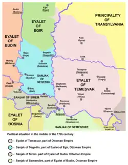
Sanjak of Segedin as part of the Eyalet of Eğri in the middle of the 17th century
Administrative divisions
Sanjak of Segedin was divided into several kazas:
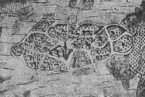
Ottoman Sonbor (Sombor) - image from 1698
Beys (governors) of the sanjak
- Hasan Pasha Predojević (1592)
See also
References
- Dr. Dušan J. Popović, Srbi u Vojvodini, knjiga 1, Novi Sad, 1990.
- Istorijski atlas, Geokarta, Beograd, 1999.
External links
- U SUBOTICI ODRŽANA PROMOCIJA PUBLIKACIJE O SEGEDINSKOM SANDŽAKU 1570. GODINE - Kako se živelo pod Turcima
- Map - location of Sanjak of Segedin
- Map of the Sanjak of Segedin
| Wikimedia Commons has media related to Sanjak of Segedin. |
This article is issued from Wikipedia. The text is licensed under Creative Commons - Attribution - Sharealike. Additional terms may apply for the media files.