Shinyanga Region
Shinyanga Region is one of Tanzania's 31 administrative regions. The regional capital is the municipality of Shinyanga. According to the 2012 national census, the region had a population of 1,534,808.[2]:page 2 For 2002-2012, the region's 2.1 percent average annual population growth rate was the twentieth highest in the country.[2]:page 4 It was also the tenth most densely populated region with 81 people per square kilometer.[2]:page 6 With a size of 50,781 square kilometres (19,607 sq mi),[3] the region is slightly smaller than Costa Rica (51,100 square kilometres (19,700 sq mi)).
Shinyanga Region
Mkoa wa Shinyanga (Swahili) | |
|---|---|
 Williamson diamond Pud stroker mine in Mwadui. | |
 Regional map before partition in 2012 | |
| Country | Tanzania |
| Zone | Lake |
| Capital | Shinyanga |
| Government | |
| • Regional Commissioner | Ali Rufunga |
| Area | |
| • Total | 18,901 km2 (7,298 sq mi) |
| Population (2012) | |
| • Total | 1,534,808 |
| • Density | 81/km2 (210/sq mi) |
| Time zone | UTC+3 (EAT) |
| Postcode | 37xxx |
| Area code(s) | 028 |
| HDI (2018) | 0.490[1] low · 20th of 25 |
| Website | Regional website |
The region is bordered to the north by the Mwanza, Mara, and Kagera Regions and to the south by the Tabora Region. Kigoma Region borders to the west, and the Simiyu Region to the east.
Districts
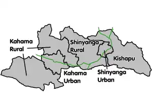
As of 2012, the region is administratively divided into six districts:[4]
| Districts of Shinyanga Region | ||||||
|---|---|---|---|---|---|---|
| Map with main roads in green | District | Population (2012 Census) | ||||
 |
Kahama Town | 242,208 | ||||
| Kishapu District | 272,990 | |||||
| Msalala District* | 250,727 | |||||
| Shinyanga District | 334,417 | |||||
| Shinyanga Municipal | 161,391 | |||||
| Ushetu District** | 273,075 | |||||
| Total | 1,534,808 | |||||
Notes:
* - representing the northeast portion of the former Kahama District
** - representing the southwest portion of the former Kahama District
Culture
The three predominant tribes of the Shinyanga region are the Sukuma, Nyamwezi, and Sumbwa tribes.
Economy
The traditional agriculture in the area varies as follows;
Food crops
- Maize
- Rice
Cash crops
- Cotton
References
- "Sub-national HDI - Area Database - Global Data Lab". hdi.globaldatalab.org. Retrieved 2020-02-26.
- Population Distribution by Administrative Units, United Republic of Tanzania, 2013 Archived June 12, 2013, at the Wayback Machine
- "Statistical Abstract 2011, Tanzania National Bureau of Statistics". Archived from the original on 2013-11-05. Retrieved 2014-06-24.
- "Census 2012". National Bureau of Statistics. Archived from the original on 2016-03-05.