Snoderån
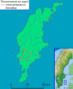
Snoderån is a 32 km (20 mi) long river on Gotland, Sweden.[1] Snoderån basin has an area of 183.3 km2 (70.8 sq mi)[2] and it has a total area of 240 km2 (93 sq mi), which represents about 8% of Gotland's area.[1] 17 socken's are situated wholly or partly within the basin and comprises (exclusive enclaves) of: Alva, Burs, Fardhem, Fröjel, Gerum, Hablingbo, Havdhem, Hejde, Hemse, Klinte, Levide, Linde, Lojsta, Rone, Silte, Sproge and Stånga. Snoderån has its source in the Lojsta area and two outflows to the west into the Baltic Sea at Kvarnåkershamn in Sproge and Silte.[1]
| Snoderån | |
|---|---|
 Map of the river Snoderån | |
| Location | |
| Country | Sweden |
| County | Gotland |
| Municipality | Gotland |
| Physical characteristics | |
| Length | 32 km (20 mi)[1] |
| Basin size | 183.3 km2 (70.8 sq mi)[2] |
References
- Amér, Katarina (2013-01-13). "Kunskapsöversikt Snoderåns avrinningsområde" (PDF) (in Swedish). South Baltic Water District. p. 6. Retrieved 8 June 2016.
- "Län och huvudavrinningsområden i Sverige" (PDF) (in Swedish). Swedish Meteorological and Hydrological Institute. November 2002. p. 3. Retrieved 16 July 2010.
This article is issued from Wikipedia. The text is licensed under Creative Commons - Attribution - Sharealike. Additional terms may apply for the media files.
