Sokuluk District
Sokuluk District (Kyrgyz: Сокулук району; Russian: Сокулукский район) is a raion (district) of the Chuy Region in northern Kyrgyzstan. Its area is 2,550 square kilometres (980 sq mi), and its resident population was 159,231 in 2009.[1] The capital lies at Sokuluk village.[2]
Sokuluk District
Сокулук району | |
|---|---|
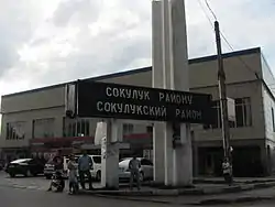
 The border to Sokuluk rayon from Alamüdün rayon along the Osh-Bishkek highway | |
 Coat of arms | |
 | |
| Country | Kyrgyzstan |
| Region | Chuy Region |
| Area | |
| • Total | 2,550 km2 (980 sq mi) |
| Population (2009)[1] | |
| • Total | 159,231 |
| • Density | 62/km2 (160/sq mi) |
| Time zone | UTC+5 (GMT +5) |
Rural communities and villages
In total, Sokuluk District include 1 town and 68 settlements in 19 rural communities (aiyl okmotus). Each rural community includes one or several villages. The rural communities and settlements in the Sokuluk District are as follows:[3]
- town Shopokov
- At-Bashi aiyl okmotu (4: center - village: Manas; and also villages Ak-Jol, Lesnoe and Tört-Köl)
- Tösh-Bulak aiyl okmotu (3: center - village: Tösh-Bulak; and also villages Börülü and Chetindi)
- Voenno-Antonovka aiyl okmotu (1: center - village: Voyenno-Antonovka)
- Gavrilovka aiyl okmotu (4: center - village: Gavrilovka; and also villages Jylamysh, Romanovka and Shalta)
- Jangy-Jer aiyl okmotu (5: center - village: Jangy-Jer; and also villages Verkhnevostochnoye, Zapadnoye, Zelenoye and Nizhnevostochnoye)
- Jangy-Pakhta aiyl okmotu (5: center - village: Jany-Pakhta; and also villages Ak-Kashat, Zarya, Mayskoye and Mirny)
- Kamyshanovka aiyl okmotu (1: center - village: Kamyshanovka)
- Asylbash aiyl okmotu (2: center - village: Asylbash; and also village Kirovskoye)
- Kuntuu aiyl okmotu (5: center - village: Kuntuu; and also villages Dostuk, Malaya Shalta, Shalta and Chong-Jar)
- Imeni Krupskoy aiyl okmotu (4: center - village: Sokuluk; and also villages Jakynky Aral, Chetki Aral and Pervoye Maya)
- Kyzyl-Tuu aiyl okmotu (5: center - village: Kyzyl-Tuu; and also villages Kara-Sakal, Malovodnoye, Novoe and Tokbay)
- Nizhnechuyskoe aiyl okmotu (6: center - village: Nizhnechuyskoye; and also villages Mirnoye, Sadovoye, Severnoye, Stepnoye and Taltak)
- Novopavlovka aiyl okmotu (2: center - village: Novopavlovka; and also village Uchkun)
- Saz aiyl okmotu (2: center - village: Saz, and also village Konush)
- Orok aiyl okmotu (8: center - village: Jal; and also villages Verkhny Orok, Kaltar, Kashka-Bash, Nizhniy Orok, Plodovoye, Sarban and Selektsionnoye)
- Pervomayskoe aiyl okmotu (3: center - village: Pervomayskoe; and also villages Natsionalnoye and Imeni Panfilova)
- Sokuluk aiyl okmotu (1: center - village Sokuluk)
- Frunze aiyl okmotu (4: center - village: Imeni Frunze, and also villages Komsomolskoye, Ozernoye and Studencheskoye)
- Imeni Kaynazarovoy aiyl okmotu (3: center - village: Chat-Köl; and also villages Belek and Tuz)
References
- "2009 population census of the Kyrgyz Republic: Chuy Region" (PDF). Archived from the original (PDF) on 10 August 2011. Retrieved 2011-08-10.
- Enrin.grida.no
- List of Rural Communities of Kyrgyzstan Archived 2010-02-09 at the Wayback Machine
This article is issued from Wikipedia. The text is licensed under Creative Commons - Attribution - Sharealike. Additional terms may apply for the media files.
