Sucre Province
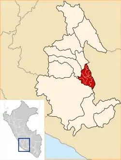
Sucre Province is a province in the eastern part of the Ayacucho Region in Peru.
Sucre | |
|---|---|
 Location of Sucre in the Ayacucho Region | |
| Country | Peru |
| Region | Ayacucho |
| UBIGEO | 0509 |
Geography
One of the highest mountains of the province is Qarwarasu at 5,112 m (16,772 ft). Other mountains are listed below:[1]
- Anta Q'asa
- Apu Pumani
- Aqu Urqu
- Chawpi Wasi
- Chillwa Chillwa
- Ch'illkacha
- Kampanayuq
- Kuyuq
- K'ark'ani
- Mach'ay Pata
- Maray Urquna
- Masu Pampa
- Muyu Muyu
- Nina Pampa
- Ñawincha
- Pallqa Urqu
- Palta Rumi
- Pampa Wasi
- Parqa Parqa
- Pata Wasi
- Pilluni
- Pinqulluna
- Pirwa
- Puywani
- Phiruru
- Qucha Urqu
- Qura Qura
- Q'ala Urqu
- Q'illu Urqu
- Rasuwillka
- Saywachayuq
- Sikuwani
- Sinqa Sinqa
- Sinqata
- Siwi Q'asa
- Sura Pata
- T'utura
- Uqi Qaqa
- Usqunta
- Wallunk'ani
- Waman Wiri
- Wamp'u
- Waraquchayuq
- Wayllani
- Wayrana
- Wit'u
- Yaku Tinku
- Yana Phaqcha
- Yana Qucha
- Yana Urqu
- Yana Yana
- Yawyu
Political division
The province is divided into eleven districts.
- Belén (Belén)
- Chalcos (Chalcos)
- Chilcayoc (Chilcayoc)
- Huacaña (Huacaña)
- Morcolla (Morcolla)
- Paico (Paico)
- Querobamba (Querobamba)
- San Pedro de Larcay (San Pedro de Larcay)
- San Salvador de Quije (San Salvador de Quije)
- Santiago de Paucaray (Santiago de Paucaray)
- Soras (Soras)
Ethnic groups
The people in the province are mainly indigenous citizens of Quechua descent. Quechua is the language which the majority of the population (76.47%) learnt to speak in childhood, 23.21% of the residents started speaking using the Spanish language (2007 Peru Census).[2]
Sources
- escale.minedu.gob.pe - UGEL maps of the Vilcas Huamán Province 2, Ayacucho Region
- inei.gob.pe Archived 2013-01-27 at the Wayback Machine INEI, Peru, Censos Nacionales 2007
This article is issued from Wikipedia. The text is licensed under Creative Commons - Attribution - Sharealike. Additional terms may apply for the media files.