Tes Lake
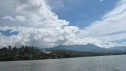
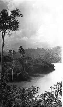
Tes Lake is a natural tourism attraction in Lebong Regency. It is one of the largest lakes in Indonesia. Lake Tes is the main Hydroelectricity (hydropower) supplier for almost whole of Bengkulu Province. The area of the lake is about 750 Ha. Located at Kutai Donok Village, it is approximately an hours travel from Muara Aman, and can be reached by most public transportation. The Central Hydroelectricity, which is only about 2 km from the lake can be visited.
| Tes Lake | |
|---|---|
 | |
 Tes Lake | |
| Location | Indonesia |
| Coordinates | 3°13′40″S 102°20′54″E |
| Type | Shrunken lake |
| Primary inflows | Ketahun River & Pauh River |
| Primary outflows | Air Putih River |
| Catchment area | 10 km2 (3.9 sq mi) |
| Basin countries | Indonesia |
| Max. length | 5 km (3.1 mi) |
| Max. width | 1 km (0.62 mi) |
| Surface area | 5 km2 (1.9 sq mi) |
| Average depth | 10 m (33 ft) |
| Max. depth | 56 m (184 ft) |
| Water volume | 0.05 km3 (41,000 acre⋅ft) |
| Shore length1 | 4 km (2.5 mi) |
| Surface elevation | 1 m (3 ft 3 in) |
| Islands | Bungin Ialand, Pasir Island, Titik Island, Saweak Island & Ujung Island |
| References | [1] |
| 1 Shore length is not a well-defined measure. | |
Details
Area description
Based on the Decree of Forestry Minister No. 385/Kpts-II/1985, December 27, 1985, Lake Tes including in an area width: 3.230 Hectares.
Potential growth of flora
The flora that grows around the area are: Meranti, Dyera costulata, Kayu Gadis, Pulai, Gelam, and other plants which also grow elsewhere in Bengkulu Province.
Fauna
Tigers, gibbons, several kinds of monkey, snakes, bears, many kinds of domestic birds, forest dogs, many types of domestic fish, and other varieties of creatures may be found in the area.
Location
Nearest village: Karang Anyar, Kutai Donok (Central Village), Talang Ratu Village and Tes Village
Subdistrict: South Lebong
Regency: Lebong
Province: Bengkulu
Geographical position
Geographically, located between 3'-11- 3'20 S and 102'-18-102'-36 E.
Topography
Generally, 600 to 950m above the sea level.
Geology and soil
Based on Geological Map and Map Prop. Land Bengkulu scale 1: 500,000:
- Structure of Geology: Rocks and Tuva Resen Vulkan
- Type of Soil: Litosol, Regosol
- Material Master: Frozen Rock and Vulcan
Climate
Based on climate division Schmidt and Feerguson including the type of climate (A).
Accessibility
To reach the location from Bengkulu City, you can use most types of vehicles.
References
- Archived March 29, 2009, at the Wayback Machine
External links
- (in English) Tourism In lebong
- (in English) Gedang Lake Tes