Texas State Highway 159
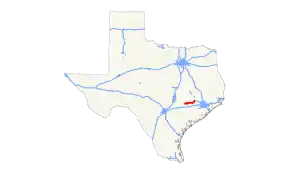
State Highway 159 (SH 159) is a Texas state highway that runs from La Grange to Fayetteville in Fayette County, through Industry and Bellville in Austin County, and ends at Hempstead in Waller County. The route was designated on March 19, 1930 from SH 73 east to Hempstead as a renumbering of SH 73A. On December 8, 1932, it extended west to northeast of La Grange, replacing part of SH 73, which had been rerouted further south earlier.[2] On September 26, 1939, SH 159 was extended to La Grange, replacing part of SH 237.
| ||||
|---|---|---|---|---|
 | ||||
| Route information | ||||
| Maintained by TxDOT | ||||
| Length | 57.73 mi[1] (92.91 km) | |||
| Existed | 1930–present | |||
| Major junctions | ||||
| West end | ||||
| East end | ||||
| Highway system | ||||
| ||||
Route description
SH 159 begins at Bus. SH 71 in downtown La Grange and heads northeast. The highway intersects with SH 71 on the outskirts of La Grange.[3]
Junction list
| County | Location | mi | km | Destinations | Notes |
|---|---|---|---|---|---|
| Fayette | La Grange | 0.0 | 0.0 | Western terminus of SH 159 | |
| 0.5 | 0.80 | ||||
| Oldenburg | 6.4 | 10.3 | |||
| 6.5 | 10.5 | ||||
| Fayetteville | 14.4 | 23.2 | |||
| 14.7 | 23.7 | Start of FM 1291 concurrency | |||
| 14.8 | 23.8 | End of FM 1291 concurrency | |||
| Willow Springs-Zapp | 21.2 | 34.1 | |||
| Austin | | 24.9 | 40.1 | ||
| Industry | 27.5 | 44.3 | |||
| | 31.8 | 51.2 | |||
| Nelsonville | 33.4 | 53.8 | |||
| Bellville | 42.1 | 67.8 | Start of SH 36 concurrency | ||
| 42.9 | 69.0 | South end of FM 1456 | |||
| 43.2 | 69.5 | End of SH 36 concurrency | |||
| 43.3 | 69.7 | ||||
| | 51.8 | 83.4 | North end of FM 1456 | ||
| Waller | | 54.9 | 88.4 | ||
| Hempstead | 58.7 | 94.5 | Eastern terminus of SH 159 | ||
| 1.000 mi = 1.609 km; 1.000 km = 0.621 mi | |||||
References
- Transportation Planning and Programming Division (n.d.). "State Highway No. 159". Highway Designation Files. Texas Department of Transportation. Retrieved 2010-06-15.
- (PDF) https://publicdocs.txdot.gov/minord/MinuteOrderDocLib/003673818.pdf. Missing or empty
|title=(help) - Google (May 15, 2013). "Texas State Highway 159" (Map). Google Maps. Google. Retrieved May 15, 2013.
This article is issued from Wikipedia. The text is licensed under Creative Commons - Attribution - Sharealike. Additional terms may apply for the media files.
