Texas State Highway 194
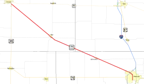
State Highway 194 (SH 194) is a 42.72-mile (68.75 km) state highway that travels from near Dimmitt southeast to Plainview in the Texas Panhandle.
| ||||
|---|---|---|---|---|
 | ||||
| Route information | ||||
| Maintained by TxDOT | ||||
| Length | 42.72 mi[1] (68.75 km) | |||
| Existed | by 1933–present | |||
| Major junctions | ||||
| Northwest end | ||||
| Southeast end | ||||
| Highway system | ||||
| ||||
History
SH 194 was designated on its current route on February 9, 1933.[2] On September 26, 1939, the designation was extended from Plainview southeast through Petersburg, then southwest through Slaton to Tahoka, replacing SH 280. On October 22, 1940, the section of SH 194 from 3.6 miles north of the Hale-Lubbock County Line to Slaton was cancelled. On November 22, 1940, the section from Plainview to 3.6 miles north of the Hale-Lubbock County Line was cancelled. On March 6, 1941, the section of SH 194 from Slaton to Tahoka was cancelled. The current route parallels the Burlington Northern railway along its entire route, except for the final half mile in Plainview.
Major intersections
| County | Location | mi | km | Destinations | Notes | |||
|---|---|---|---|---|---|---|---|---|
| Castro | | 0.0 | 0.0 | Northwestern terminus | ||||
| Hart | 15.1 | 24.3 | ||||||
| | 15.7 | 25.3 | ||||||
| Swisher |
No major junctions | |||||||
| Hale | | 25.7 | 41.4 | |||||
| 25.9 | 41.7 | |||||||
| Edmonson | 29.3 | 47.2 | Runs concurrently to SH 194 for 1.0 mile (1.6 km) | |||||
| | 30.4 | 48.9 | ||||||
| Plainview | 39.9 | 64.2 | ||||||
| 42.0 | 67.6 | |||||||
| 42.7 | 68.7 | Southern terminus | ||||||
| 1.000 mi = 1.609 km; 1.000 km = 0.621 mi | ||||||||
References
- Transportation Planning and Programming Division (n.d.). "State Highway No. 194". Highway Designation Files. Texas Department of Transportation. Retrieved 2010-06-15.
- (PDF) https://publicdocs.txdot.gov/minord/MinuteOrderDocLib/003673825.pdf. Missing or empty
|title=(help)
