Tiradentes, Minas Gerais
Tiradentes is a municipality in the Brazilian state of Minas Gerais. It is located at 21°06′37″S 44°12′41″W, has an area of 83.5 km², and a maximum elevation above sea level of 927 m. Tiradentes had an estimated population of 10,960, as of 2020. The original village was established in 1702 and became a city on 19 January 1718. In 1889 the city was renamed from São José del Rey in honour of the national hero who was born nearby.
Tiradentes | |
|---|---|
Municipality | |
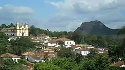 Downtown Tiradentes | |
 Seal | |
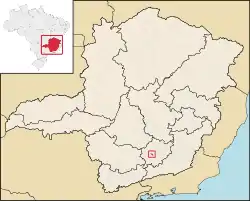 Location in the State of Minas Gerais | |
| Coordinates: 21°06′31″S 44°10′28″W | |
| Country | |
| Region | Southeast |
| State | |
| Population (2020 [1]) | |
| • Total | 10,960 |
| Time zone | UTC-3 (BST) |
| • Summer (DST) | UTC-2 (BDT) |
| Postal Code | 36325-000 |
It has been acclaimed as an unspoiled example of Portuguese colonial architecture.
See also
- A section of the Estrada de Ferro Oeste de Minas narrow gauge railway from São João del-Rei to Tiradentes has been preserved as a tourist line.
References
External links
| Wikimedia Commons has media related to Tiradentes (Minas Gerais). |
| Wikivoyage has a travel guide for Tiradentes. |
Capital: Belo Horizonte | |||||||||||||||||||||||||
|  | ||||||||||||||||||||||||
|
| |||||||||||||||||||||||||
| |||||||||||||||||||||||||
| |||||||||||||||||||||||||
| |||||||||||||||||||||||||
| |||||||||||||||||||||||||
| |||||||||||||||||||||||||
| |||||||||||||||||||||||||
| |||||||||||||||||||||||||
| |||||||||||||||||||||||||
| |||||||||||||||||||||||||
| Authority control |
|---|
This article is issued from Wikipedia. The text is licensed under Creative Commons - Attribution - Sharealike. Additional terms may apply for the media files.