Tropical Storm Grace (2003)
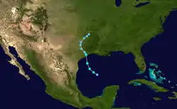
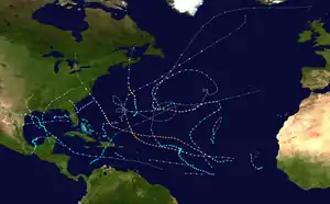
Tropical Storm Grace was a weak tropical storm that struck Texas in the 2003 Atlantic hurricane season. The eleventh tropical depression and the seventh tropical storm of the season, Grace was also the weakest storm of the season. On August 30 the storm developed from a long-track tropical wave in the western Gulf of Mexico. Grace remained disorganized throughout its lifetime due to an upper level low to its west. The weak storm moved northwestward and made landfall on southeastern Texas. Grace quickly weakened over land, and dissipated on September 2 as it merged into a cold front.
| Tropical storm (SSHWS/NWS) | |
 Tropical Storm Grace weakening over Texas on August 31 | |
| Formed | August 30, 2003 |
|---|---|
| Dissipated | September 2, 2003 |
| Highest winds | 1-minute sustained: 40 mph (65 km/h) |
| Lowest pressure | 1007 mbar (hPa); 29.74 inHg |
| Fatalities | None reported |
| Damage | $113,000 (2003 USD) |
| Areas affected | Texas, Oklahoma, Ohio Valley, Mid-Atlantic States |
| Part of the 2003 Atlantic hurricane season | |
In Texas, the storm dropped heavy rainfall, causing minor flash flooding damage. The cold front, combined with the remnants of the storm, dropped moderate to heavy rainfall from Texas through the Mid-Atlantic. The worst of the flooding occurred in Indianapolis, where record rainfall affected over 700 homes. Despite the rainfall, damage was minimal along its path.
Meteorological history

A strong tropical wave accompanied with a low pressure system moved off the coast of Africa on August 19. It moved quickly westward and organized, developing banding features and cirrus outflow near the blossoming convection. The wave nearly developed into a tropical cyclone on August 21, though its fast forward motion dislocated the low level circulation from the deep convection. The wave entered an area of dry air in the central Atlantic Ocean, and by late on August 22 most of the convection dissipated from the system. On August 24, convection increased as the wave passed through the Lesser Antilles, though strong southwesterly upper level wind shear prevented further development. The tropical wave moved through the Caribbean Sea, and developed deep convection due to more favorable conditions over the Gulf of Honduras on August 28. The wave crossed the Yucatán Peninsula, and developed a surface low pressure area on the 29th in the Gulf of Mexico. Convection continued to organize, and the tropical wave developed into Tropical Depression Eleven on August 30 while located 335 miles (540 km) east-southeast of Corpus Christi, Texas.[1]
The depression moved to the northwest, and intensified into Tropical Storm Grace six hours after forming. Despite the increase in winds the center of circulation remained very broad, with Reconnaissance Aircraft having difficulty pinpointing the center. In addition, an upper level low located over Brownsville, Texas produced shear over the western portion of the system, which limited outflow to the east side. Forecasters predicted the upper level low to weaken, allowing for the possibility of Grace to intensify to a 65 mph (100 km/h) tropical storm over warm waters.[2] However, the upper level low remained in place and continued to produce shear across the system. A new center of circulation reformed 115 miles (185 km) north of the original center, and made landfall near San Luis Pass on the southwestern portion of Galveston Island on August 31 as a minimal tropical storm. Grace quickly weakened to a tropical depression over land, and after turning northeastward into Oklahoma the depression was absorbed by a cold front.[1]
Preparations
Three hours after forming, officials issued Tropical Storm Warnings from High Island to Corpus Christi, Texas.[1] Local National Weather Service offices requested a voluntary evacuation for western Galveston Island including Jamaica Beach, the Bolivar Peninsula, and coastal areas of Brazoria and Matagorda counties,[3] though few residents heeded the warnings. Local emergency management officials predicted tides of up to 5 feet (1.5 m) above normal with coastal flooding.[4]
Impact

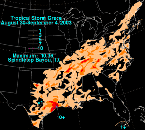
Grace produced moderate amounts of rainfall along its path, peaking in southern Texas. The storm later merged with a cold front, which later dropped heavy rainfall in the Mid-West United States. In addition to its impact on the United States, the outer rainbands of Grace caused light rainfall in Yucatán and northern Tamaulipas.[5]
South-Central United States
Upon making landfall, Tropical Storm Grace produced a light storm surge of 3.5 feet (1 m) in Matagorda and North Jetty, Texas. Wind gusts peaked at 53 mph (85 km/h) with sustained winds of 40 mph (64 km/h) at Sea Rim State Park. Locations closer to where the storm made landfall reported below tropical storm force winds, with the exception of Galveston which recorded a 40 mph (64 km/h) wind gust.[1] Rainfall was moderate to heavy across eastern Texas, peaking at 10.36 inches (263 mm) in Spindletop Bayou.[6] The outer bands of Grace spawned a waterspout just south of the western tip of Galveston Island, prompting the issuance of a tornado warning. The waterspout dissipated before moving onshore. The storm also caused light beach erosion, though little occurred beyond the erosion caused by Hurricane Claudette one month prior.[3] Near the coast, high tides from the storm flooded piers, bulkheads, and low-lying areas.[4] Further inland, heavy rainfall lead to flash flooding, covering roads and entering a few houses. Overall, damage was minor, and totaled to $113,000 (2003 USD, $147,100 2016 USD).[7][8]
In Oklahoma, moisture from the storm, combined with a slow-moving cold front, produced heavy rainfall across the state, peaking at 8.98 inches (228 mm) in Courtney. Due to below normal precipitation by as much as 5 to 10 inches (127 to 255 mm), flooding was localized and overall minimal. Near Medford, the rainfall led to 2 feet (0.6 m) deep flooding on U.S. Highway 81, forcing its closure. The rainfall was welcome in the state, and lessened the rainfall deficit.[9]
Tropical Storm Grace, combined with the slow-moving cold front, produced light to moderate rainfall totals across the southern United States, including isolated locations in Louisiana and Mississippi reporting over 3 inches (76 mm) and over 5 inches (127 mm) in northeastern Arkansas.[6]
Ohio Valley and Eastern United States
In Missouri, the cold front combined with moisture from the remnants of Grace brought temporary relief to a severe drought[10] by producing light to moderate rainfall of up to 5 inches (127 mm) in the southeastern portion of the state.[6] In Poplar Bluff, the rainfall caused severe flooding, resulting in rescues for people in trapped vehicles.[11] The moisture produced over 5 inches (127 mm) in northern Kentucky, as well.[6]
Moisture from the remnants of Grace dropped heavy rainfall across central Indiana, including a record one-day total of 7 inches (178 mm) in Indianapolis, while other locations received over 9 inches (228 mm). Residents prepared sand bags to prevent overflowing rivers and creeks, though rising waters entered streets and over 700 homes. The rapid rainfall in Indianapolis backed up the sewage system, sending hundreds of millions of gallons of sewage into the streets. Following the deluge in the state, the governor declared a state of emergency for the state. Eight local American Red Cross chapters arrived to provide meals and aid to the affected people.[12]
The remnants of Grace dropped moderate to heavy rainfall eastward through the Mid-Atlantic States and New England. Locations in extreme western Maryland and southeastern Virginia received over 5 inches (127 mm) of rain.[6] In Maryland, Hagerstown recorded 3.94 inches (100 mm), resulting in flash flooding. In Washington County, the system produced 1.09 inches (27.8 mm) of rain, a new daily record. Damage in Maryland, if any, was unknown.[13]
See also
References
| Wikimedia Commons has media related to Tropical Storm Grace (2003). |
- Stacy R. Stewart (2003). "Tropical Storm Grace Tropical Cyclone Report" (PDF). National Hurricane Center. Retrieved May 22, 2015.
- Stewart (2003). "Tropical Storm Grace Discussion Two". NHC. Retrieved 2006-08-13.
- Blood/Oettinger/Hafele (2003). "Tropical Storm Grace Preliminary Report". Houston/Galveston National Weather Service. Archived from the original on January 6, 2006. Retrieved 2006-08-14.
- Jim O'Donnel (2003). "Tropical Storm Grace Preliminary Storm Report". Jamaica Beach Weather Observatory. Retrieved 2006-08-14.
- Servicio Meteorológico Nacional (2003). "Tormenta Tropical "Grace" del Océano Atlántico". Archived from the original on October 4, 2006. Retrieved 2006-10-08.
- Hydrometeorological Prediction Center (2005). "Rainfall data for Tropical Storm Grace". Retrieved 2006-08-16.
- National Climatic Data Center (2003). "Event Report for Tropical Storm Grace". Retrieved 2006-08-16.
- National Climatic Data Center (2003). "Event Report for Tropical Storm Grace (2)". Retrieved 2006-08-16.
- Ty Judd (2003). "The 2003 Labor Day Weekend Heavy Rain and Flooding Event". Norman, Oklahoma National Weather Service. Archived from the original on June 4, 2006. Retrieved 2006-08-18.
- Missouri Department of Conservation (2003). "Missouri Forest Health 2003 Highlights" (PDF). Archived from the original (PDF) on October 2, 2006. Retrieved 2006-08-18.
- Paducah, Kentucky National Weather Service (2003). "Autumn 2003 Weather Summary". Retrieved 2006-08-18.
- Mason Booth (2003). "Central Indiana Declares State of Emergency". RedCross.org. Archived from the original on 2008-12-02. Retrieved 2006-08-20.
- Atlantic Coast Observer Network (2003). "Isabel, Henri, and Grace; Three Names to Remember" (PDF). Archived from the original (PDF) on 2012-02-04. Retrieved 2006-08-20.
