U.S. Route 24 in Colorado
U.S. Route 24 (US 24) is a part of the U.S. Highway System that travels from Minturn, Colorado, to Clarkston, Michigan. In the U.S. state of Colorado US 24 extends from Interstate 70 (I-70) and US 6 in Minturn east to the Kansas state line where it continues as US 24 concurrent with I-70.
| ||||
|---|---|---|---|---|
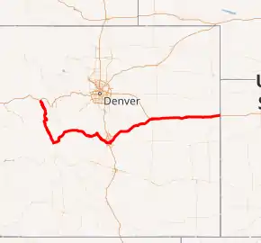
US 24 highlighted in red | ||||
| Route information | ||||
| Maintained by CDOT | ||||
| Length | 323.24 mi[1] (520.21 km) | |||
| Existed | 1936[2]–present | |||
| Major junctions | ||||
| West end | ||||
| East end | ||||
| Location | ||||
| Counties | Eagle, Lake, Chaffee, Park, Teller, El Paso, Elbert, Lincoln, Kit Carson | |||
| Highway system | ||||
|
Colorado State Highways
| ||||

Route description
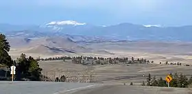
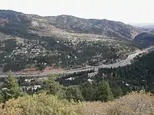
US 24 traverses the Rocky Mountains, starting near Minturn. It then continues southeast for about 30 miles to Leadville, where it turns south and goes to Buena Vista where it becomes concurrent with US 285. It continues with Highway 285 to the small community of Antero Junction. After that, it spends its time as a mountainous two-lane highway until it gets to the town of Divide, where it meets SH 67 and becomes a 4 lane highway. These highways overlap to Woodland Park. From there it passes through Crystola, Green Mountain Falls, and Cascade. Through Manitou Springs and Colorado Springs, where the road is known as Midland Expressway. Just east of Interstate 25, it is known as the Martin Luther King Jr Bypass. From Colorado Springs it continues northeast through several towns such as Falcon, Peyton, the city of Calhan, Ramah, Simla, and Matheson. When US 24 reaches Limon, it junctions with I-70/US 40/US 287/SH 71. It continues east (parallel to I-70) to Burlington where it joins I-70 to the Kansas state line.
Junction list
NOTE: The mile reference column values are NOT mile markers. Current (Jan. 2021) mile information can be found here: CDOT OTIS data
| County | Location | mi[3] | km | Destinations | Notes | ||
|---|---|---|---|---|---|---|---|
| Eagle | Minturn | 0 | 0.0 | (MM 143) Western terminus of US 24; I-70 exit 171 | |||
| Lake | Leadville | 31 | 50 | (MM 176) | |||
| | 47 | 76 | |||||
| Chaffee | Johnson Village | 68.5 | 110.2 | (MM 213) South end of US 285 overlap | |||
| Park | | 82 | 132 | North end of US 285 overlap | |||
| Hartsel | 94 | 151 | (MM 239) | ||||
| Teller | Divide | 132 | 212 | (MM 278) West end of SH 67 overlap | |||
| Woodland Park | 139.5 | 224.5 | East end of SH 67 overlap | ||||
| | 145 | 233 | Pikes Peak Highway | ||||
| El Paso | Manitou Springs | 150 | 240 | ||||
| 153 | 246 | ||||||
| Colorado Springs | 158 | 254 | (MM 304) West end of I-25 overlap; I-25 exit 141 | ||||
| 159 | 256 | Northern Terminus of SH-115; I-25 exit 140 | |||||
| 160 | 260 | East end of I-25 overlap; I-25 exit 139 | |||||
| 161.5 | 259.9 | Union Boulevard | Interchange; | ||||
| 163 | 262 | Interchange; Westbound exit, Eastbound entrance; West end of Fountain Blvd overlap | |||||
| 164.5 | 264.7 | ||||||
| 167 | 269 | East end of Fountain Blvd overlap West end of SH 21/Powers Blvd overlap | |||||
| 168 | 270 | Airport Road east – Peterson Air Force Base | |||||
| 168 | 270 | Stewart Avenue | Interchange; eastbound entrance only | ||||
| 169 | 272 | East end of SH 21/Powers Blvd overlap; SH 21 Exit 141 | |||||
| 169 | 272 | Platte Avenue west – Downtown Colorado Springs | |||||
| 169.5 | 272.8 | Interchange; | |||||
| | 170.5 | 274.4 | Western Terminus of SH-94 | ||||
| Falcon | 178 | 286 | Woodmen Road | ||||
| | 180 | 290 | Judge Orr Road east – Meadow Lake Airport | ||||
| | 183 | 295 | |||||
| Peyton | 188 | 303 | Peyton Highway | ||||
| | 192 | 309 | Ellicott Highway | ||||
| Calhan | 198 | 319 | Calhan Highway | (MM 340) | |||
| Elbert | Simla | 211 | 340 | Connects to SH 86 | |||
| Matheson | 218 | 351 | Connects to SH 86 | ||||
| Lincoln | Limon | 230 | 370 | (MM 377) West end of US 40/US 287 overlap | |||
| 231 | 372 | West end of SH 71 overlap | |||||
| 232 | 373 | East end of SH 71 overlap | |||||
| 233 | 375 | I-70 exit 361 | |||||
| | 234 | 377 | East end of US 40/US 287 overlap; West end of I-70 overlap; I-70 exit 363 | ||||
| See I-70 | |||||||
| Kit Carson | Seibert | 277 | 446 | East end of overlap of I-70; I-70 exit 405 | |||
| 277.5 | 446.6 | ||||||
| Stratton | 293 | 472 | |||||
| Burlington | 309 | 497 | West end of US 385 overlap | ||||
| 310 | 500 | East end of US 385 overlap | |||||
| 310.5 | 499.7 | West end of I-70 overlap; I-70 exit 438 | |||||
| | 318 | 512 | Kansas state line; Eastern terminus of US 24 in Colorado | ||||
1.000 mi = 1.609 km; 1.000 km = 0.621 mi
| |||||||
References
- Colorado Department of Transportation, Highway Data Archived 2007-10-08 at the Wayback Machine, accessed July 2008
- Salek, Matthew E. "Colorado Routes 20-39". Retrieved 2010-12-31.
- Colorado Department of Transportation, Highway Data Archived 2007-10-08 at the Wayback Machine, accessed October 2007: note that not every interval between mileposts is exactly a mile, explaining why more exits than expected are at the exact milepost
| Previous state: Terminus |
Colorado | Next state: Kansas |