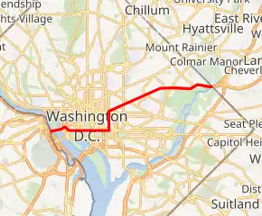
U.S. Route 50 in the District of Columbia
U.S. Route 50 (US 50) is a major east–west route of the U.S. Highway system, stretching just over 3,000 miles (4,800 km) from Ocean City, Maryland, on the Atlantic Ocean, to West Sacramento, California, nearly to the Pacific Ocean. In the District of Columbia, US 50 passes between Arlington County, Virginia, and Prince George's County, Maryland, predominantly along surface streets, including a part of Constitution Avenue along the National Mall.
| ||||
|---|---|---|---|---|
US 50 highlighted in red | ||||
| Route information | ||||
| Maintained by DDOT | ||||
| Length | 7.7 mi[1] (12.4 km) | |||
| Major junctions | ||||
| West end | ||||
| ||||
| East end | ||||
| Highway system | ||||
| ||||

Route description
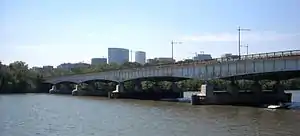
US 50 enters the District of Columbia from Arlington, Virginia, merging with I-66 on the Theodore Roosevelt Bridge over the Potomac River. US 50 traffic exits I-66 onto Constitution Avenue along the north side of the National Mall, passing the Lincoln Memorial, the Vietnam Veterans Memorial, the White House, the World War II Memorial, and the Washington Monument, then traveling between Federal Triangle's office buildings on the north and the Smithsonian Institution's National Museum of American History, National Museum of Natural History, and a National Gallery of Art sculpture garden to its south.
_at_the_north_end_of_Interstate_395_(Center_Leg_Freeway)_in_Washington%252C_D.C..jpg.webp)
Near the National Gallery of Art, US 50 turns left onto 6th Street NW, and after several blocks, right onto New York Avenue. The northern terminus of I-395 is at a signaled intersection with New York Avenue and 4th Street NW. At that intersection, traffic from New York Avenue in either direction may turn south onto I-395, but traffic on northbound I-395 may turn only right (east) onto New York Avenue, but not west toward downtown Washington. US 1 northbound runs concurrently with US 50 along Constitution Avenue from 14th Street NW to 6th Street NW, and along 6th Street from Constitution Avenue to New York Avenue.
The route continues northeast on New York Avenue through Northeast Washington, passing the United States National Arboretum. US 1 Alternate is concurrent with US 50 along New York Avenue between 6th Street NW and Bladensburg Road. Beyond the Arboretum, New York Avenue becomes a freeway, with an off-level interchange with South Dakota Avenue, NE in the Fort Lincoln area. US 50 then crosses the Anacostia River and continues into Maryland, where it becomes the John Hanson Highway and intersects the Baltimore-Washington Parkway.
History
The New York Avenue Industrial Freeway, if built, would have replaced New York Avenue as U.S. Route 50 east of Interstate 395.
Major intersections
The entire route is in Washington. All exits are unnumbered.
| Location | mi[1] | km | Destinations | Notes | |
|---|---|---|---|---|---|
| Potomac River | 0.0 | 0.0 | Continuation into Virginia | ||
| 0.2 | 0.32 | George Washington Parkway north | Westbound exit only | ||
| Western end of I-66 concurrency; westbound exit and eastbound entrance | |||||
| 0.2– 0.5 | 0.32– 0.80 | Eastern end of Theodore Roosevelt Bridge | |||
| Foggy Bottom | Independence Avenue | Eastbound exit and westbound entrance | |||
| 0.6 | 0.97 | Eastern end of I-66 concurrency; eastbound exit and westbound entrance | |||
| 0.8 | 1.3 | 23rd Street NW | Eastern end of freeway section | ||
| National Mall | 1.8 | 2.9 | Western end of concurrency with US 1 | ||
| 2.0 | 3.2 | 12th Street Expressway | Northern end of one-way expressway; inbound access only | ||
| 2.2 | 3.5 | Northern end of one-way expressway; outbound access only | |||
| Downtown | 2.5 | 4.0 | Southern terminus of US 1 Alternate; no direct southbound access | ||
| Mount Vernon Square | 3.2 | 5.1 | Eastern end of concurrency with US 1 | ||
| 3.4 | 5.5 | Northern terminus of I-395; future I-195; 4th Street NW is a one-way street, southbound access only | |||
| NoMa | 3.8 | 6.1 | North Capitol Street | Grade-separated interchange | |
| Gateway | 6.0 | 9.7 | |||
| 6.7 | 10.8 | 36th Place NE | Western end of freeway section; eastbound exit and entrance | ||
| Fort Lincoln | 7.1 | 11.4 | South Dakota Avenue / Fort Lincoln Drive | No westbound entrance | |
| Anacostia Park | 7.7 | 12.4 | Continuation into Maryland | ||
1.000 mi = 1.609 km; 1.000 km = 0.621 mi
| |||||
References
- Google (December 3, 2016). "U.S. 50" (Map). Google Maps. Google. Retrieved December 3, 2016.
External links
| Wikimedia Commons has media related to U.S. Route 50 in the District of Columbia. |
- District of Columbia Highway(s), from Yurasko.net
- Washington D.C. Interstates and Freeways, from Roads to the Future
| Previous state: Virginia |
District of Columbia | Next state: Maryland |