UTC−05:00
UTC−05:00 is an identifier for a time offset from UTC of −05:00. In North America, it is observed in the Eastern Time Zone during standard time, and in the Central Time Zone during the other eight months (see Daylight saving time). The western Caribbean uses it year round.
| UTC−05:00 | |
|---|---|
| time zone | |
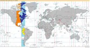 World map with the time zone highlighted | |
| UTC offset | |
| UTC | UTC−05:00 |
| Current time | |
| 08:45, 5 February 2021 UTC−05:00 [refresh] | |
| Central meridian | |
| 75 degrees W | |
| Date-time group | |
| R | |
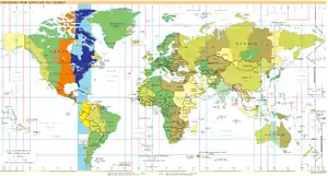
UTC−05:00: blue (January), orange (July), yellow (all year round), light blue (sea areas)
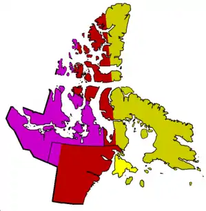
Time in Nunavut
| Standard | DST | ||
|---|---|---|---|
| GMT−05:00 | GMT−04:00 | Eastern Time | |
| GMT−05:00 (year round) | Eastern Time | ||
| GMT−06:00 | GMT−05:00 | Central Time | |
| GMT−07:00 | GMT−06:00 | Mountain Time | |
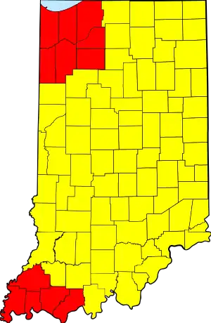
Time in Indiana: Counties grouped by time zone. Lake Michigan shown in blue at top left.
| Standard | DST | US time zone | |
|---|---|---|---|
| Red | UTC−06:00 | UTC−05:00 | Central Time |
| Yellow | UTC−05:00 | UTC−04:00 | Eastern Time |
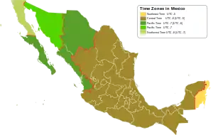
Time in Mexico
| Winter | Summer (DST) | Mexican time zone | North American equivalent | |
|---|---|---|---|---|
| UTC−05:00 | Zona Sureste | Eastern Time | ||
| UTC−06:00 | UTC−05:00 | Zona Centro | Central Time | |
| UTC−07:00 | UTC−06:00 | Zona Pacífico | Mountain Time | |
| UTC−07:00 | ||||
| UTC−08:00 | UTC−07:00 | Zona Noroeste | Pacific Time | |
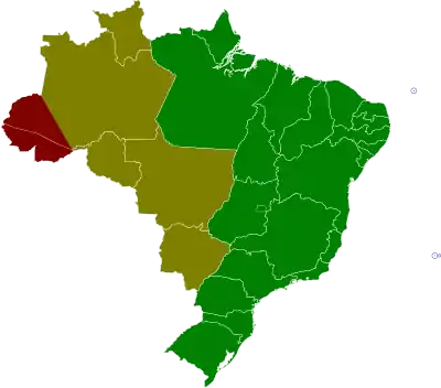
Time in Brazil, since April 25, 2019.
| ACT | Acre Time | UTC−5 | (BRT–2) | |
| AMT | Amazon Time | UTC−4 | (BRT−1) | |
| BRT | Brasília Time | UTC−3 | (BRT) | |
| FNT | Fernando de Noronha Time | UTC−2 | (BRT+1) |
As standard time (Northern Hemisphere winter)
Principal cities: New York, Toronto, Havana
North America
.svg.png.webp) Canada (Eastern Time Zone)
Canada (Eastern Time Zone)
 United States (Eastern Time Zone)[2]
- Delaware
- District of Columbia
- Florida
- Entire state except the counties of Bay, Calhoun, Escambia, Holmes, Jackson, Okaloosa, Santa Rosa, Walton, and Washington, and northern Gulf county (panhandle)
- Georgia
- Indiana[3]
- Kentucky
- Maryland
- Michigan[4]
- New England (states of Connecticut, Massachusetts, Maine, New Hampshire, Rhode Island and Vermont)[2]
- New Jersey
- New York
- North Carolina
- Ohio
- Pennsylvania
- South Carolina
- Tennessee
- Virginia
- West Virginia
Caribbean
As daylight saving time (Northern Hemisphere summer)
Principal cities: Mexico City, Chicago, Winnipeg
North America
- Canada (Central Time Zone)
 Mexico
- All except Baja California, Baja California Sur, Chihuahua, Nayarit, Quintana Roo, Sinaloa and Sonora.[5]
- United States (Central Time Zone)
- Alabama
- Arkansas
- Florida
- The counties of Bay, Calhoun, Escambia, Holmes, Jackson, Okaloosa, Santa Rosa, Walton, and Washington, and northern Gulf county (panhandle)[2]
- Illinois
- Indiana[3]
- Iowa
- Kansas
- Entire state except westernmost counties
- Kentucky
- Louisiana
- Michigan[4]
- Minnesota
- Mississippi
- Missouri
- Nebraska
- Central and eastern Nebraska
- North Dakota
- Entire state except southwest
- Oklahoma
- Entire state except Kenton
- South Dakota
- Eastern half
- Tennessee
- Texas
- All except westernmost counties
- Wisconsin
As standard time (all year round)
Principal cities: Bogotá, Lima, Kingston
Central and South America
 Brazil[8]
- Acre
- Amazonas (13 western municipalities, approximately marked by a line between Tabatinga and Porto Acre)
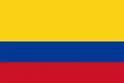 Colombia – Time in Colombia
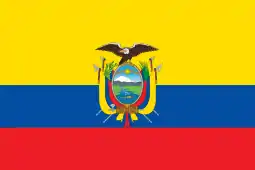 Ecuador – Time in Ecuador (except Galápagos Islands)
 Panama
 Peru – Time in Peru
North America
As daylight saving time (Southern Hemisphere summer)
East Pacific
See also
References
- "Ontario Time Zone – Ontario Current Local Time – Daylight Saving Time". TimeTemperature.com. Retrieved 1 February 2015.
- "Time Zones of the United States". Statoids. Retrieved 25 August 2012.
- "Time zone map (spring)" (PDF). Indiana State. 13 March 2011. Retrieved 14 July 2012.
- "Michigan Time Zone – Michigan Current Local Time – Daylight Saving Time". TimeTemperature.com. Retrieved 25 August 2012.
- "Hora Oficial en los Estados Unidos Mexicanos" (in Spanish). Centro Nacional de Metrologîa. 11 November 2010. Retrieved 14 July 2012.
- "Kentucky County Map". Kentucky Map Collection. Geology.com. Retrieved 6 October 2012.
- "Tennessee County Map". Tennessee Map Collection. Geology.com. Retrieved 6 October 2012.
- "Brazil: Acre and parts of Amazonas switch time zones". Time and Date. 31 October 2013 [9 October 2013]. Retrieved 17 November 2013.
- "Navassa Island". WorldTimeZone. Retrieved 6 October 2012.
This article is issued from Wikipedia. The text is licensed under Creative Commons - Attribution - Sharealike. Additional terms may apply for the media files.