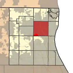
Warren Township, Lake County, Illinois
Warren Township is a township in Lake County, Illinois, USA. As of the 2010 census, its population was 64,841.[2] The cities of Gurnee, Gages Lake, Park City, Grayslake, Grandwood Park, and Wildwood lie within its borders. The township was established in 1850 by settlers who came from the town of Warren, New York. Both were named in honor of Major General Joseph Warren, killed at the Battle of Bunker Hill.[3]
Warren Township | |
|---|---|
 Location in Lake County | |
 Lake County's location in Illinois | |
| Coordinates: 42°22′20″N 87°56′54″W | |
| Country | United States |
| State | Illinois |
| County | Lake |
| Established | November 6, 1849 |
| Government | |
| • Supervisor | Suzanne D. Simpson |
| Area | |
| • Total | 36.76 sq mi (95.21 km2) |
| • Land | 35.97 sq mi (93.17 km2) |
| • Water | 2.03 sq mi (2.03 km2) 2.14% |
| Elevation | 709 ft (216 m) |
| Population (2010) | |
| • Estimate (2016)[1] | 64,297 |
| • Density | 1,642/sq mi (634/km2) |
| Time zone | UTC-6 (CST) |
| • Summer (DST) | UTC-5 (CDT) |
| FIPS code | 17-097-78877 |
| Website | www |
Geography
Warren Township covers an area of 36.76 square miles (95.2 km2); of this, 0.78 square miles (2.0 km2) or 2.03 percent is water. Lakes in this township include Gages Lake, Grandwood Lake, Twin Lakes and Valley Lake.
Cities and towns
- Gages Lake
- Grandwood Park
- Grayslake (east edge)
- Gurnee (vast majority)
- Old Mill Creek (south quarter)
- Park City (west three-quarters)
- Third Lake (east quarter)
- Wadsworth (south edge)
- Waukegan (partial)
- Wildwood
Adjacent townships
- Newport Township (north)
- Benton Township (northeast)
- Waukegan Township (east)
- Shields Township (southeast)
- Libertyville Township (south)
- Fremont Township (southwest)
- Avon Township (west)
- Lake Villa Township (west)
Cemeteries
The township contains seven cemeteries: Highland Memorial Park, Sant Sava Monastery, Serbian Monastery, Spaulding, Spaulding Corners, Swan Family and Warren.
Major highways
- Interstate 94
- U.S. Route 41
- U.S. Route 45
- Illinois Route 21
- Illinois Route 43
- Illinois Route 120
- Illinois Route 131
- Illinois Route 132
Airports and landing strips
- O John Clark RLA Airport (historical)[4]
Railroad lines
References
- "Population and Housing Unit Estimates". Retrieved June 9, 2017.
- "U.S. Census website". Retrieved 2008-05-30.
- "Gurnee History - Warren Township". The Village of Gurnee, IL. Archived from the original on 2007-08-05. Retrieved 2007-08-02.
- "Google Maps". Google. Retrieved 28 October 2012.
- "Census of Population and Housing". Census.gov. Retrieved June 4, 2016.