Washington Township, Washington County, Indiana
Washington Township is one of thirteen townships in Washington County, Indiana, United States. As of the 2010 census, its population was 10,176 and it contained 4,543 housing units.[1]
Washington Township | |
|---|---|
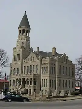
 The Washington County Courthouse in Salem | |
 Location in Washington County | |
| Coordinates: 38°36′49″N 86°06′07″W | |
| Country | United States |
| State | Indiana |
| County | Washington |
| Government | |
| • Type | Indiana township |
| Area | |
| • Total | 75.31 sq mi (195.1 km2) |
| • Land | 74.95 sq mi (194.1 km2) |
| • Water | 0.36 sq mi (0.9 km2) 0.48% |
| Elevation | 764 ft (233 m) |
| Population (2010) | |
| • Total | 10,176 |
| • Density | 135.8/sq mi (52.4/km2) |
| ZIP code | 47167 |
| GNIS feature ID | 0454023 |
Geography
According to the 2010 census, the township has a total area of 75.31 square miles (195.1 km2), of which 74.95 square miles (194.1 km2) (or 99.52%) is land and 0.36 square miles (0.93 km2) (or 0.48%) is water.[1]
Cities, towns, villages
- Salem (the county seat)
Unincorporated towns
- Canton at 38.623947°N 86.034698°W
- Fair Acres at 38.604224°N 86.090255°W
- Harristown at 38.597836°N 86.024142°W
- Highland at 38.649501°N 86.127479°W
- Hitchcock at 38.638112°N 86.169703°W
- Martin Heights at 38.612557°N 86.108034°W
- McCol Place at 38.609224°N 86.114423°W
(This list is based on USGS data and may include former settlements.)
Adjacent townships
- Monroe Township (north)
- Gibson Township (northeast)
- Franklin Township (east)
- Polk Township (southeast)
- Pierce Township (south)
- Howard Township (southwest)
- Vernon Township (west)
- Jefferson Township (northwest)
Cemeteries
The township contains these thirteen cemeteries: Blue River Hicksite, Blue River Quaker Orthodox, Coggswell, McKnight, New Philadelphia, Nicholson, Norris, Old Hebron, Paynter, Poor Farm, Stalker, Winslow and Wright.
Airports and landing strips
- Hardin Airport
- Salem Municipal Airport
Education
- Salem Community Schools
Washington Township is served by the Salem-Washington Township Public Library.[2]
Political districts
- Indiana's 9th congressional district
- State House District 73
- State Senate District 44
References
- United States Census Bureau 2007 TIGER/Line Shapefiles
- United States Board on Geographic Names (GNIS)
- IndianaMap
- "Population, Housing Units, Area, and Density: 2010 - County -- County Subdivision and Place -- 2010 Census Summary File 1". United States Census. Archived from the original on 2020-02-12. Retrieved 2013-05-10.
- "Indiana public library directory" (PDF). Indiana State Library. Retrieved 15 March 2018.