Weidenberg
Weidenberg is a municipality in the district of Bayreuth in Bavaria in Germany. The Ölschnitz river discharges near Weidenberg-Neunkirchen into the Red Main.
Weidenberg | |
|---|---|
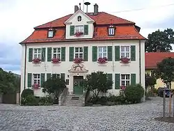
 Town hall | |
 Coat of arms | |
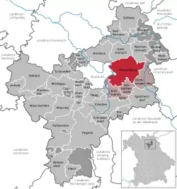
Location of Weidenberg within Bayreuth district  | |
 Weidenberg  Weidenberg | |
| Coordinates: 49°56′32″N 11°43′13″E | |
| Country | Germany |
| State | Bavaria |
| Admin. region | Oberfranken |
| District | Bayreuth |
| Municipal assoc. | Weidenberg |
| Subdivisions | 52 Ortsteile |
| Government | |
| • Mayor | Hans Wittauer (FW) |
| Area | |
| • Total | 68.91 km2 (26.61 sq mi) |
| Highest elevation | 853 m (2,799 ft) |
| Lowest elevation | 357 m (1,171 ft) |
| Population (2019-12-31)[1] | |
| • Total | 5,799 |
| • Density | 84/km2 (220/sq mi) |
| Time zone | UTC+01:00 (CET) |
| • Summer (DST) | UTC+02:00 (CEST) |
| Postal codes | 95466 |
| Dialling codes | 09278 / 09209 / 0921 |
| Vehicle registration | BT |
| Website | www.weidenberg.de |
Nearby is the site of a medieval castle, known as Burgstall Schlosshügel.
References
- "Tabellenblatt "Daten 2", Statistischer Bericht A1200C 202041 Einwohnerzahlen der Gemeinden, Kreise und Regierungsbezirke". Bayerisches Landesamt für Statistik und Datenverarbeitung (in German). July 2020.
This article is issued from Wikipedia. The text is licensed under Creative Commons - Attribution - Sharealike. Additional terms may apply for the media files.