Yarowilca Province
The Yarowilca Province is the smallest of eleven provinces of the Huánuco Region in Peru. The capital of this province is Chavinillo.
Yarowilca | |
|---|---|
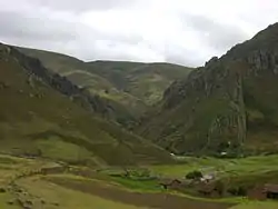
 Isi Pampa in the Jacas Chico District | |
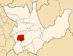
 Location of Yarowilca in the Huánuco Region | |
| Country | Peru |
| Region | Huánuco |
| Capital | Chavinillo |
| Government | |
| • Mayor | Rubino Aguirre Solorzano |
| Area | |
| • Total | 759.71 km2 (293.33 sq mi) |
| Population (2005 census) | |
| • Total | 38,813 |
| • Density | 51/km2 (130/sq mi) |
| UBIGEO | 1011 |
Boundaries
- North: Dos de Mayo Province
- East: Huánuco Province
- South: Lauricocha Province
- West: Dos de Mayo Province
Geography
One of the highest peaks of the district is Qullqa Punta at 4,542 m (14,902 ft). Other mountains are listed below:[1]
- Atuq Wachanan
- Awkin Qaqa
- Hatun Uqhu Punta
- Huch'uy Yaku
- Ichik Yanama
- Inka Wayin
- Isu Pampa
- Kachi Pampa Punta
- Kimsa Ukru Punta
- Kunkush Punta
- Kuntur Mach'ay
- Laksha Warina
- Mata Punta
- Mata Qaqa Punta
- Mina Punta
- Para Qucha Punta
- Puka Qucha
- Puka Rumi Punta
- Puma Wayin
- P'itiq Punta
- Rumi Sunqu
- Ruphay Punta
- Siklla Raqra Punta
- Silla Kancha
- Tuqtuqucha Punta
- T'akaq
- Uqsha P'itiq
- Wank'ayuq
- Wari Punta
- Warmi Rumi
- Waylla Punta
- Wichhu Qullpa
- Wiñaq Punta
- Wiru Wiru
- Yana Qucha
- Yana Tutu
- Yanashallash
Political division
The province is divided into eight districts, which are:
- Aparicio Pomares (Chupan)
- Cahuac (Cahuac)
- Chacabamba (Chacabamba)
- Chavinillo (Chavinillo)
- Choras (Choras)
- Jacas Chico (San Cristóbal de Jacas Chico)
- Obas (Obas)
- Pampamarca (Pampamarca)
Ethnic groups
The people in the province are mainly indigenous citizens of Quechua descent. Quechua is the language which the majority of the population (60.97%) learnt to speak in childhood, 38.74% of the residents started speaking using the Spanish language (2007 Peru Census).[2]
Archaeology
Some of the most important archaeological sites of the province are Awkillu Waqra, T'akaq, Wallpayunka, Warahirka, Waruq and Wich'un.
Sources
- escale.minedu.gob.pe/ UGEL map Huacaybamba Province (Huánuco Region)
- inei.gob.pe INEI, Peru, Censos Nacionales 2007
This article is issued from Wikipedia. The text is licensed under Creative Commons - Attribution - Sharealike. Additional terms may apply for the media files.